
Fai una donazione
Preparati per la tua prossima avventura:
In qualità di associato Amazon, questo sito riceve una commissione sugli acquisti idonei senza alcun costo aggiuntivo per te.
Mappa topografica Kavaratti
Clicca sulla mappa per visualizzare l'altitudine.
Fai una donazione
Preparati per la tua prossima avventura:
In qualità di associato Amazon, questo sito riceve una commissione sugli acquisti idonei senza alcun costo aggiuntivo per te.
Kavaratti
The atoll of Kavaratti lies 360 km (220 mi) off the Malabar coast of mainland India. The island is 5.6 km (3.5 mi) long, and 1.6 km (0.99 mi) wide, and occupies an area of 4.22 km2 (1.63 sq mi). It is surrounded by a 6 km (3.7 mi) long lagoon with an area of 4.96 km2 (1.92 sq mi). It is located to the east of Agatti and to the west of Andrott islands. The island gently slopes from the west to east, with an average altitude of 2 to 5 m (6 ft 7 in to 16 ft 5 in) on the west and 2 to 3 m (6 ft 7 in to 9 ft 10 in) on the eastern side. The soil is mostly sandy or loamy. Kavaratti has an inland lake in the northern part of the island and numerous small ponds and wells. The island is surrounded by coral reefs that support various marine life.
Fai una donazione
Preparati per la tua prossima avventura:
In qualità di associato Amazon, questo sito riceve una commissione sugli acquisti idonei senza alcun costo aggiuntivo per te.
A proposito di questa mappa
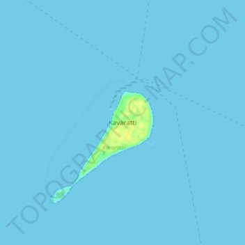
Nome: Mappa topografica Kavaratti, altitudine, rilievo.
Luogo: Kavaratti, Lakshadweep, 262240, India (10.52722 72.59946 10.60722 72.67946)
Altitudine media: 0 m
Altitudine minima: 0 m
Altitudine massima: 17 m
Fai una donazione
Preparati per la tua prossima avventura:
In qualità di associato Amazon, questo sito riceve una commissione sugli acquisti idonei senza alcun costo aggiuntivo per te.
Altre mappe topografiche
Clicca su una mappa per visualizzarne la topografia, l'altitudine e il rilievo.
Kavaratti Island
India > Lakshadweep > Kavaratti > Kavaratti
The island of Kavaratti lies 360 km (190 nmi) off the coast of the state of Kerala at 10°34′N 72°38′E / 10.57°N 72.64°E / 10.57; 72.64. It has an average elevation of 0 metres (0 feet).
Altitudine media: 2 m