

Mappa topografica Mount Hood
Clicca sulla mappa per visualizzare l'altitudine.
Mount Hood
Mount Hood, also known as Wy'east, is an active stratovolcano in the Cascade Range and is a member of the Cascade Volcanic Arc. It was formed by a subduction zone on the Pacific Coast and rests in the Pacific Northwest region of the United States. It is located about 50 miles (80 km) east-east-southeast of Portland, on the border between Clackamas and Hood River counties, and forms part of the Mount Hood National Forest. Much of the mountain outside the ski areas is part of the Mount Hood Wilderness. With a summit elevation of 11,249 feet (3,429 m), it is the highest mountain in the U.S. state of Oregon and is the fourth highest in the Cascade Range. Ski areas on the mountain include Timberline Lodge ski area which offers the only year-round lift-served skiing in North America, Mount Hood Meadows, Mount Hood Skibowl, Summit Ski Area, and Cooper Spur ski area. Mt. Hood attracts an estimated 10,000 climbers a year.
A proposito di questa mappa
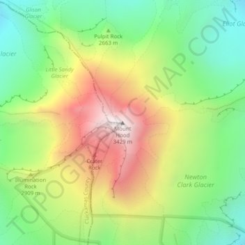
Nome: Mappa topografica Mount Hood, altitudine, rilievo.
Luogo: Mount Hood, Hood River County, Oregon, United States (45.37346 -121.69593 45.37356 -121.69583)
Altitudine media: 2.716 m
Altitudine minima: 2.213 m
Altitudine massima: 3.416 m
Altre mappe topografiche
Clicca su una mappa per visualizzarne la topografia, l'altitudine e il rilievo.
Hood River
United States > Oregon > Hood River County
Temperatures for the year as a whole are slightly cooler than in most other low-elevation towns in the region, especially at night because of air drainage off the surrounding mountains.
Altitudine media: 112 m

Wyeth State Recreation Area
United States > Oregon > Hood River County > Cascade Locks
Altitudine media: 163 m
