
Mappa topografica Minot
Mappa interattiva
Clicca sulla mappa per visualizzare l'altitudine.
A proposito di questa mappa
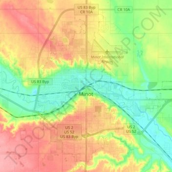
Nome: Mappa topografica Minot, altitudine, rilievo.
Luogo: Minot, Ward County, North Dakota, United States (48.19164 -101.34295 48.28304 -101.18767)
Altitudine media: 510 m
Altitudine minima: 467 m
Altitudine massima: 558 m
The elevation of the river at the city center is 1,540 feet (470 m) above sea level. The valley sits 160 feet (49 m) below the surrounding plains; the elevation at the Minot International Airport on North Hill is 1,716 feet (523 m). The city has several small horseshoe-shaped oxbow lakes within its limits near the river, created by the Mouse's meandering course.