
Fai una donazione
Preparati per la tua prossima avventura:
In qualità di associato Amazon, questo sito riceve una commissione sugli acquisti idonei senza alcun costo aggiuntivo per te.
Mappa topografica Mount Phillips
Clicca sulla mappa per visualizzare l'altitudine.
Fai una donazione
Preparati per la tua prossima avventura:
In qualità di associato Amazon, questo sito riceve una commissione sugli acquisti idonei senza alcun costo aggiuntivo per te.
A proposito di questa mappa
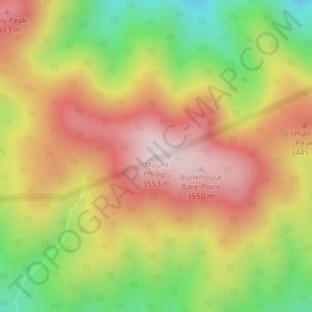
Nome: Mappa topografica Mount Phillips, altitudine, rilievo.
Luogo: Mount Phillips, Colfax County, New Mexico, United States (36.47662 -105.15955 36.47672 -105.15945)
Altitudine media: 3.308 m
Altitudine minima: 3.002 m
Altitudine massima: 3.574 m
Fai una donazione
Preparati per la tua prossima avventura:
In qualità di associato Amazon, questo sito riceve una commissione sugli acquisti idonei senza alcun costo aggiuntivo per te.
Altre mappe topografiche
Clicca su una mappa per visualizzarne la topografia, l'altitudine e il rilievo.
Angel Fire
United States > New Mexico > Colfax County
Angel Fire is located in southwestern Colfax County at 36°22′44″N 105°17′8″W / 36.37889°N 105.28556°W / 36.37889; -105.28556 (36.378808, -105.285658). The village center is in the valley of Cieneguilla Creek, with housing developments climbing mountain slopes to the east and west. Angel…
Altitudine media: 2.786 m
Raton
United States > New Mexico > Colfax County
Sugarite Canyon State Park is located 12 miles (19 km) northeast of Raton at an elevation of 8,800 feet (2,700 m). Activities there include camping, fishing, and hiking.
Altitudine media: 2.040 m
Fai una donazione
Preparati per la tua prossima avventura:
In qualità di associato Amazon, questo sito riceve una commissione sugli acquisti idonei senza alcun costo aggiuntivo per te.
Lake Maloya
United States > New Mexico > Colfax County
Lake Maloya is a reservoir in Sugarite Canyon State Park on the New Mexico-Colorado State border, northeast of Raton, New Mexico. It is the main source of water for the city and its outlying areas. When full, the lake's surface has an elevation of 7,516 feet (2,291 meters).
Altitudine media: 2.387 m
Angel Fire
United States > New Mexico > Colfax County
Angel Fire is located in southwestern Colfax County. The village center is in the valley of Cieneguilla Creek, with housing developments climbing mountain slopes to the east and west. Angel Fire Resort, entirely within the village limits, is on the east side of the valley, with a base elevation of 8,600 feet…
Altitudine media: 2.786 m
Fai una donazione
Preparati per la tua prossima avventura:
In qualità di associato Amazon, questo sito riceve una commissione sugli acquisti idonei senza alcun costo aggiuntivo per te.
Angel Fire
United States > New Mexico > Colfax County
Angel Fire is located in southwestern Colfax County. The village center is in the valley of Cieneguilla Creek, with housing developments climbing mountain slopes to the east and west. Angel Fire Resort, entirely within the village limits, is on the east side of the valley, with a base elevation of 8,600 feet…
Altitudine media: 2.786 m
Lake Maloya
United States > New Mexico > Colfax County
Lake Maloya is a reservoir in Sugarite Canyon State Park on the New Mexico-Colorado State border, northeast of Raton, New Mexico. It is the main source of water for the city and its outlying areas. When full, the lake's surface has an elevation of 7,516 feet (2,291 meters).
Altitudine media: 2.387 m
Fai una donazione
Preparati per la tua prossima avventura:
In qualità di associato Amazon, questo sito riceve una commissione sugli acquisti idonei senza alcun costo aggiuntivo per te.