
Fai una donazione
Preparati per la tua prossima avventura:
In qualità di associato Amazon, questo sito riceve una commissione sugli acquisti idonei senza alcun costo aggiuntivo per te.
Mappa topografica Ephrata
Clicca sulla mappa per visualizzare l'altitudine.
Fai una donazione
Preparati per la tua prossima avventura:
In qualità di associato Amazon, questo sito riceve una commissione sugli acquisti idonei senza alcun costo aggiuntivo per te.
Ephrata
The settlement of Ephrata is quite recent. There was no known settlement until 1886, just three years before Washington gained statehood. The horse rancher Frank Beezley was the first to settle near the natural springs, thus the area was known as Beezley Springs. As the climate and topography were not promising to settlement, the entire region remained sparsely populated until several federal congressional actions, including the Northern Pacific Land Grant Act, the Homestead Act, and Desert Claims Act, encouraged the settlement of this semi-arid desert-like area. Originally, Douglas County spread over the entire territory of the Big Bend of the Columbia River. In 1909, the Washington State legislature divided it, creating Grant County. When the time came to present arguments to the state legislature regarding which town should be the county seat, someone apparently intentionally intoxicated the representative of a rival community, and Ephrata was chosen.
Fai una donazione
Preparati per la tua prossima avventura:
In qualità di associato Amazon, questo sito riceve una commissione sugli acquisti idonei senza alcun costo aggiuntivo per te.
A proposito di questa mappa
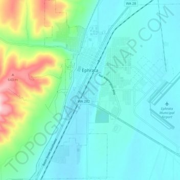
Nome: Mappa topografica Ephrata, altitudine, rilievo.
Luogo: Ephrata, Grant County, Washington, 98823, United States (47.28070 -119.58373 47.34123 -119.49620)
Altitudine media: 434 m
Altitudine minima: 373 m
Altitudine massima: 685 m
Fai una donazione
Preparati per la tua prossima avventura:
In qualità di associato Amazon, questo sito riceve una commissione sugli acquisti idonei senza alcun costo aggiuntivo per te.
Altre mappe topografiche
Clicca su una mappa per visualizzarne la topografia, l'altitudine e il rilievo.