
Mappa topografica Spences Bridge
Mappa interattiva
Clicca sulla mappa per visualizzare l'altitudine.
A proposito di questa mappa
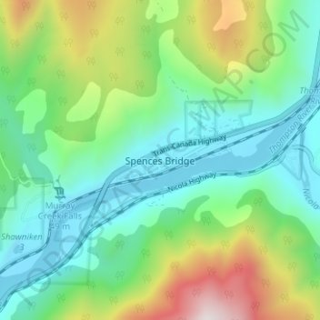
Nome: Mappa topografica Spences Bridge, altitudine, rilievo.
Altitudine media: 495 m
Altitudine minima: 213 m
Altitudine massima: 1.195 m
Spences Bridge's location is mountainous, with higher elevations part of the Interior Plateau. The east side of the Fraser here is part of the Clear Range, a mountainous southwards extension of the Fraser Plateau located in the angle of the Thompson and Fraser Rivers. Arthur Seat lies in that range on the west side of Spences Bridge, and was named by pioneer John Murray for Arthur's Seat in Edinburgh, Scotland.
Altre mappe topografiche
Clicca su una mappa per visualizzarne la topografia, l'altitudine e il rilievo.
Walhachin
Canada > British Columbia > Thompson-Nicola Regional District > Area I (Blue Sky Country)
Walhachin, Area I (Blue Sky Country), Thompson-Nicola Regional District, British Columbia, Canada
Altitudine media: 438 m
Barnes Lake
Canada > British Columbia > Thompson-Nicola Regional District > Area I (Blue Sky Country)
Barnes Lake, Area I (Blue Sky Country), Thompson-Nicola Regional District, British Columbia, Canada
Altitudine media: 752 m
Shaw Springs
Canada > British Columbia > Thompson-Nicola Regional District > Area I (Blue Sky Country)
Shaw Springs, Area I (Blue Sky Country), Thompson-Nicola Regional District, British Columbia, Canada
Altitudine media: 472 m