Geolocalizza

Mappa topografica Kuruva Island

Clicca sulla mappa per visualizzare l'altitudine.

A proposito di questa mappa

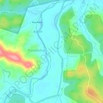
Nome: Mappa topografica Kuruva Island, altitudine, rilievo.

Luogo: Kuruva Island, Sulthanbathery, Wayanad District, Kerala, India (11.80550 76.08514 11.83762 76.09906)

Altitudine media: 733 m

Altitudine minima: 704 m

Altitudine massima: 817 m

Altre mappe topografiche

Clicca su una mappa per visualizzarne la topografia, l'altitudine e il rilievo.

Kenichira

India > Kerala > Sulthanbathery

Altitudine media: 788 m

Sultan Bathery

India > Kerala > Sulthanbathery

Sulthan Bathery is located at 11°40′N 76°17′E / 11.67°N 76.28°E / 11.67; 76.28. It has an average elevation of 907 m (2,976 ft).

Altitudine media: 876 m

Sulthan Bathery

India > Kerala > Sulthanbathery > Sultan Bathery

Altitudine media: 873 m

Marakavu

India > Kerala > Sulthanbathery > Pulpally

Altitudine media: 769 m

Kenichira

India > Kerala > Sulthanbathery

Altitudine media: 770 m

Nellarachal

India > Kerala > Sulthanbathery

Altitudine media: 781 m

Vadakkanad

India > Kerala > Sulthanbathery

Altitudine media: 896 m

Edakkal

India > Kerala > Sulthanbathery > Ambalavayal

Altitudine media: 927 m

Kalluvayal

India > Kerala > Sulthanbathery > Pulpally

Altitudine media: 816 m

Nadavayal

India > Kerala > Sulthanbathery

Altitudine media: 751 m

Seethamount

India > Kerala > Sulthanbathery > Kabanigiri

Altitudine media: 731 m

Ambalavayal

India > Kerala > Sulthanbathery

Altitudine media: 880 m

Meenangadi

India > Kerala > Sulthanbathery

Altitudine media: 760 m

Muthanga

India > Kerala > Sulthanbathery

Altitudine media: 866 m

Koliyadi

India > Kerala > Sulthanbathery

Altitudine media: 886 m

Paplassery

India > Kerala > Sulthanbathery

Altitudine media: 795 m

Sulthan Bathery

India > Kerala > Sulthanbathery > Sultan Bathery

Altitudine media: 873 m

Muthanga

India > Kerala > Sulthanbathery

Altitudine media: 866 m

Meenangadi

India > Kerala > Sulthanbathery

Altitudine media: 760 m

Sultan Bathery

India > Kerala > Sulthanbathery

Sultan Bathery is located at 11°40′N 76°17′E / 11.67°N 76.28°E / 11.67; 76.28, on the Kozhikode–Kollegal National Highway (NH 766) 97 kilometers from Kozhikode. It is 114 km from Mysore and about 100 km from Ooty (Udagamandalam). It is also connected with Nilambur. It has an average…

Altitudine media: 876 m

Sultan Bathery

India > Kerala > Sulthanbathery

Sulthan Bathery is located at 11°40′N 76°17′E / 11.67°N 76.28°E / 11.67; 76.28. It has an average elevation of 907 m (2,976 ft).

Altitudine media: 876 m

Ambalavayal

India > Kerala > Sulthanbathery

Altitudine media: 880 m

Preparati per la tua prossima avventura:

🧊Borse Frigo e Ghiaccio - Soluzioni per mantenere freschi cibi e bevande durante le gite
🥤Filtri Acqua Potabile - Dispositivi per potabilizzare l'acqua di fiumi e torrenti
🧥Giacche softshell - Giacche traspiranti per attività outdoor
🦯Bastoncini da Trekking - Bastoni leggeri in alluminio o carbonio per ridurre il carico sulle articolazioni
🧣Scaldacollo Tubolari - Accessorio versatile per proteggere collo, testa o viso

In qualità di associato Amazon, questo sito riceve una commissione sugli acquisti idonei senza alcun costo aggiuntivo per te.