
Mappa topografica Dunsfold
Clicca sulla mappa per visualizzare l'altitudine.
Dunsfold
St Mary & All Saints' Church is a Norman building, containing the oldest pews in England. The nearby Holy Well was a site of pilgrimage – its waters were thought to cure diseases of the eye. It would be consistent with the topography of the site that the well be a pre-Christian site and the church itself be constructed on a man-made hill of pre-Christian origin.
A proposito di questa mappa
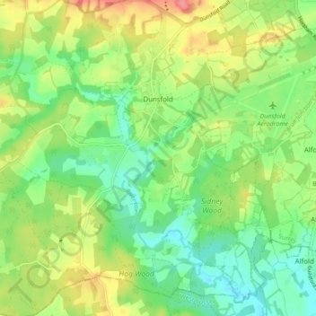
Nome: Mappa topografica Dunsfold, altitudine, rilievo.
Luogo: Dunsfold, Waverley, Surrey, England, United Kingdom (51.07968 -0.59778 51.13305 -0.53668)
Altitudine media: 52 m
Altitudine minima: 22 m
Altitudine massima: 97 m
Altre mappe topografiche
Clicca su una mappa per visualizzarne la topografia, l'altitudine e il rilievo.
Camelsdale
United Kingdom > England > Surrey > Waverley > Haslemere > Shottermill
Altitudine media: 166 m
Hankley Common
United Kingdom > England > Surrey > Waverley > Thursley > Truxford
Altitudine media: 70 m
Floodplain (seasonal)
United Kingdom > England > Surrey > Waverley > Farnham > Wrecclesham
Altitudine media: 94 m