
Fai una donazione
Preparati per la tua prossima avventura:
In qualità di associato Amazon, questo sito riceve una commissione sugli acquisti idonei senza alcun costo aggiuntivo per te.
Mappa topografica Pine Township
Clicca sulla mappa per visualizzare l'altitudine.
Fai una donazione
Preparati per la tua prossima avventura:
In qualità di associato Amazon, questo sito riceve una commissione sugli acquisti idonei senza alcun costo aggiuntivo per te.
Pine Township
The villages of Oregon Hill and English Center were founded by survivors of the failed English Settlement. Oregon Hill, at an elevation of 1,700 feet (520 m) in the northern part of the township, was the location of two churches, a blacksmith shop, and two stores along with several homes. The settlers of Oregon Hill were surprised to find that the land in the area was fertile unlike much of the surrounding land. English Center on Little Pine Creek was a milling town.
Fai una donazione
Preparati per la tua prossima avventura:
In qualità di associato Amazon, questo sito riceve una commissione sugli acquisti idonei senza alcun costo aggiuntivo per te.
A proposito di questa mappa
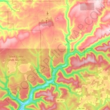
Nome: Mappa topografica Pine Township, altitudine, rilievo.
Altitudine media: 493 m
Altitudine minima: 235 m
Altitudine massima: 680 m
Fai una donazione
Preparati per la tua prossima avventura:
In qualità di associato Amazon, questo sito riceve una commissione sugli acquisti idonei senza alcun costo aggiuntivo per te.
Altre mappe topografiche
Clicca su una mappa per visualizzarne la topografia, l'altitudine e il rilievo.
Little Pine Creek
United States > Pennsylvania > Lycoming County > Pine Township
Altitudine media: 436 m
Susquehanna State Park
United States > Pennsylvania > Lycoming County > Williamsport
Altitudine media: 206 m
Fai una donazione
Preparati per la tua prossima avventura:
In qualità di associato Amazon, questo sito riceve una commissione sugli acquisti idonei senza alcun costo aggiuntivo per te.
Steam Valley
United States > Pennsylvania > Lycoming County > Cogan House Township
Altitudine media: 539 m
Fai una donazione
Preparati per la tua prossima avventura:
In qualità di associato Amazon, questo sito riceve una commissione sugli acquisti idonei senza alcun costo aggiuntivo per te.