
Fai una donazione
Preparati per la tua prossima avventura:
In qualità di associato Amazon, questo sito riceve una commissione sugli acquisti idonei senza alcun costo aggiuntivo per te.
Mappa topografica Udumalaipettai
Clicca sulla mappa per visualizzare l'altitudine.
Fai una donazione
Preparati per la tua prossima avventura:
In qualità di associato Amazon, questo sito riceve una commissione sugli acquisti idonei senza alcun costo aggiuntivo per te.
Udumalaipettai
The town is surrounded by Western Ghats on three sides. The average altitude of the town is 1208 feet above MSL. The topography is undulated and the general slope is from west to North. The town gets major rainfall during the South West monsoon. The average annual rainfall is 501.40 mm. Black and red soil types are found in the town containing alumina and gypsum. While black soil area is utilized for agriculture, the areas with red soil have more urbanized uses.
Fai una donazione
Preparati per la tua prossima avventura:
In qualità di associato Amazon, questo sito riceve una commissione sugli acquisti idonei senza alcun costo aggiuntivo per te.
A proposito di questa mappa
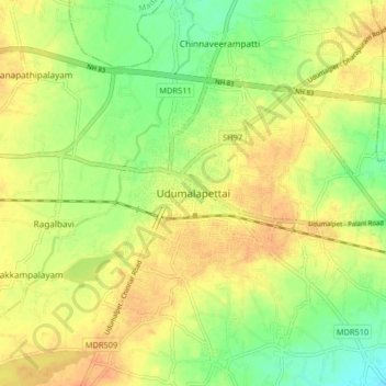
Nome: Mappa topografica Udumalaipettai, altitudine, rilievo.
Luogo: Udumalaipettai, Tiruppur, Tamil Nadu, 642100, India (10.54390 77.21000 10.62390 77.29000)
Altitudine media: 363 m
Altitudine minima: 340 m
Altitudine massima: 381 m
Fai una donazione
Preparati per la tua prossima avventura:
In qualità di associato Amazon, questo sito riceve una commissione sugli acquisti idonei senza alcun costo aggiuntivo per te.
Altre mappe topografiche
Clicca su una mappa per visualizzarne la topografia, l'altitudine e il rilievo.
Udumalaippettai
India > Tamil Nadu > Udumalaipettai
The town is surrounded by Western Ghats on three sides. The average altitude of the town is 1208 feet above MSL. The topography is undulated and the general slope is from west to North. The town gets major rainfall during the South West monsoon. The average annual rainfall is 501.40 mm. Black and red soil…
Altitudine media: 365 m