
Mappa topografica Brookfield
Mappa interattiva
Clicca sulla mappa per visualizzare l'altitudine.
Brookfield
According to the United States Census Bureau, the town has a total area of 23.2 square miles (60.2 km2), of which 22.8 sq mi (59.1 km2) are land and 0.42 sq mi (1.1 km2) are water, comprising 1.82% of the town.[1] Brookfield is drained primarily by the Branch River and Pike Brook, within the Piscataqua River (coastal) watershed, though the western edge of the town is in the Merrimack River watershed and the northernmost tip of the town is in the Saco River watershed.[5] Copple Crown Mountain, along the western border of Brookfield and the highest point in town, has an elevation of 1,868 feet (569 m) above sea level.
A proposito di questa mappa
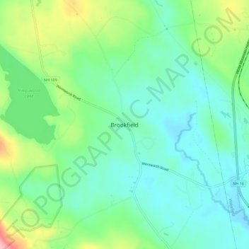
Nome: Mappa topografica Brookfield, altitudine, rilievo.
Altitudine media: 195 m
Altitudine minima: 152 m
Altitudine massima: 296 m