
Fai una donazione
Preparati per la tua prossima avventura:
In qualità di associato Amazon, questo sito riceve una commissione sugli acquisti idonei senza alcun costo aggiuntivo per te.
Mappa topografica White City
Clicca sulla mappa per visualizzare l'altitudine.
Fai una donazione
Preparati per la tua prossima avventura:
In qualità di associato Amazon, questo sito riceve una commissione sugli acquisti idonei senza alcun costo aggiuntivo per te.
A proposito di questa mappa
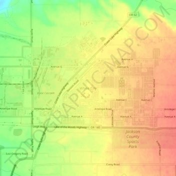
Nome: Mappa topografica White City, altitudine, rilievo.
Luogo: White City, Jackson County, Oregon, 97503, United States (42.41198 -122.85880 42.45198 -122.81880)
Altitudine media: 404 m
Altitudine minima: 370 m
Altitudine massima: 423 m
Fai una donazione
Preparati per la tua prossima avventura:
In qualità di associato Amazon, questo sito riceve una commissione sugli acquisti idonei senza alcun costo aggiuntivo per te.
Altre mappe topografiche
Clicca su una mappa per visualizzarne la topografia, l'altitudine e il rilievo.
Central Point
United States > Oregon > Jackson County
The city lies at an elevation of about 1,272 feet (388 m) along Oregon Highway 99 and Interstate 5 northwest of Medford. Jacksonville is to the south and Gold Hill to the northwest. The Central Oregon and Pacific Railroad passes through Central Point.
Altitudine media: 385 m
Lost Creek Lake
United States > Oregon > Jackson County
The primary purpose of the dam is flood control and is operated in conjunction with Applegate Dam to regulate water flows down the river as well as to impound water for summer use. The dam is an earthfill structure with a gated spillway and contains two hydroelectric generating units with a total capacity of…
Altitudine media: 729 m
Fai una donazione
Preparati per la tua prossima avventura:
In qualità di associato Amazon, questo sito riceve una commissione sugli acquisti idonei senza alcun costo aggiuntivo per te.