
Fai una donazione
Preparati per la tua prossima avventura:
In qualità di associato Amazon, questo sito riceve una commissione sugli acquisti idonei senza alcun costo aggiuntivo per te.
Mappa topografica Franklin Mountain
Clicca sulla mappa per visualizzare l'altitudine.
Fai una donazione
Preparati per la tua prossima avventura:
In qualità di associato Amazon, questo sito riceve una commissione sugli acquisti idonei senza alcun costo aggiuntivo per te.
A proposito di questa mappa
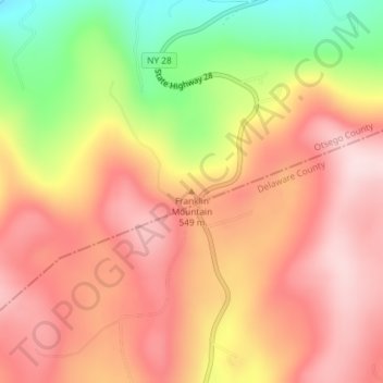
Nome: Mappa topografica Franklin Mountain, altitudine, rilievo.
Altitudine media: 533 m
Altitudine minima: 342 m
Altitudine massima: 651 m
Fai una donazione
Preparati per la tua prossima avventura:
In qualità di associato Amazon, questo sito riceve una commissione sugli acquisti idonei senza alcun costo aggiuntivo per te.
Altre mappe topografiche
Clicca su una mappa per visualizzarne la topografia, l'altitudine e il rilievo.
Canadarago Lake
United States > New York > Otsego County > Town of Richfield
It is geologically related to the Finger Lakes, as they were both carved by glaciers, but is not counted among them. One difference is that Canadarago Lake is situated at a higher elevation (1,266 feet [386 m]) than the Finger Lakes (approximately 400 feet [122 m]). Another difference is the Finger Lakes are…
Altitudine media: 443 m
Fai una donazione
Preparati per la tua prossima avventura:
In qualità di associato Amazon, questo sito riceve una commissione sugli acquisti idonei senza alcun costo aggiuntivo per te.
Burlington Flats
United States > New York > Otsego County > Town of Burlington
Altitudine media: 448 m
Fai una donazione
Preparati per la tua prossima avventura:
In qualità di associato Amazon, questo sito riceve una commissione sugli acquisti idonei senza alcun costo aggiuntivo per te.
Town of Edmeston
United States > New York > Otsego County
The elevation of the town varies by approximately 800 feet (240 m): from just under 1,100 feet (340 m) above sea level at the Unadilla River in the southwestern corner of the town, to just over 1,900 feet (580 m) at peaks near Taylor Hill and Summit Lake in the northeastern corner.
Altitudine media: 441 m
Fai una donazione
Preparati per la tua prossima avventura:
In qualità di associato Amazon, questo sito riceve una commissione sugli acquisti idonei senza alcun costo aggiuntivo per te.
Town of Exeter
United States > New York > Otsego County
The eastern town line borders, in part, Canadarago Lake. Wharton Creek flows down the western side of the town. Angel Hill is an elevation near the southern town line.
Altitudine media: 486 m
Fai una donazione
Preparati per la tua prossima avventura:
In qualità di associato Amazon, questo sito riceve una commissione sugli acquisti idonei senza alcun costo aggiuntivo per te.