
Fai una donazione
Preparati per la tua prossima avventura:
In qualità di associato Amazon, questo sito riceve una commissione sugli acquisti idonei senza alcun costo aggiuntivo per te.
Mappa topografica Cambridge
Clicca sulla mappa per visualizzare l'altitudine.
Fai una donazione
Preparati per la tua prossima avventura:
In qualità di associato Amazon, questo sito riceve una commissione sugli acquisti idonei senza alcun costo aggiuntivo per te.
Cambridge
The city, like most of the UK, has a maritime climate highly influenced by the Gulf Stream. Located in the driest region of Britain, Cambridge's rainfall averages around 570 mm (22.44 in) per year, around half the national average, The driest recent year was in 2011 with 380.4 mm (14.98 in) of rain at the Botanic Garden and 347.2 mm (13.67 in) at the NIAB site. This is just below the semi-arid precipitation threshold for the area, which is 350mm of annual precipitation. Conversely, 2012 was the wettest year on record, with 812.7 mm (32.00 in) reported. Snowfall accumulations are usually small, in part because of Cambridge's low elevation, and low precipitation tendency during transitional snow events.
Fai una donazione
Preparati per la tua prossima avventura:
In qualità di associato Amazon, questo sito riceve una commissione sugli acquisti idonei senza alcun costo aggiuntivo per te.
A proposito di questa mappa
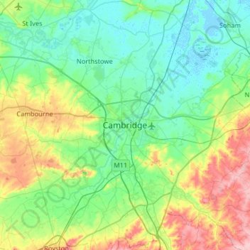
Nome: Mappa topografica Cambridge, altitudine, rilievo.
Altitudine media: 33 m
Altitudine minima: -4 m
Altitudine massima: 130 m
Fai una donazione
Preparati per la tua prossima avventura:
In qualità di associato Amazon, questo sito riceve una commissione sugli acquisti idonei senza alcun costo aggiuntivo per te.
Altre mappe topografiche
Clicca su una mappa per visualizzarne la topografia, l'altitudine e il rilievo.
Cambridge
United Kingdom > England > Cambridgeshire
The city, like most of the UK, has a maritime climate highly influenced by the Gulf Stream. Located in the driest region of Britain, Cambridge's rainfall averages around 570 mm (22.44 in) per year, around half the national average, The driest recent year was in 2011 with 380.4 mm (14.98 in) of rain at the…
Altitudine media: 18 m
Great Shelford
United Kingdom > England > Cambridgeshire > South Cambridgeshire
Altitudine media: 22 m
Fai una donazione
Preparati per la tua prossima avventura:
In qualità di associato Amazon, questo sito riceve una commissione sugli acquisti idonei senza alcun costo aggiuntivo per te.
Ely
United Kingdom > England > Cambridgeshire
Ely is built on a 23-square-mile (60 km2) Kimmeridge Clay island which, at 85 feet (26 m), is the highest land in the Fens. It was due to this topography that Ely was not waterlogged like the surrounding Fenland, and was an island separated from the mainland. Major rivers including the Witham, Welland, Nene…
Altitudine media: 4 m
Fai una donazione
Preparati per la tua prossima avventura:
In qualità di associato Amazon, questo sito riceve una commissione sugli acquisti idonei senza alcun costo aggiuntivo per te.
River Great Ouse or Ely Ouse
United Kingdom > England > Cambridgeshire > East Cambridgeshire > Soham > Stuntney
Altitudine media: 4 m
Fai una donazione
Preparati per la tua prossima avventura:
In qualità di associato Amazon, questo sito riceve una commissione sugli acquisti idonei senza alcun costo aggiuntivo per te.
Brampton
United Kingdom > England > Cambridgeshire > Huntingdonshire > Brampton
Altitudine media: 22 m
Fai una donazione
Preparati per la tua prossima avventura:
In qualità di associato Amazon, questo sito riceve una commissione sugli acquisti idonei senza alcun costo aggiuntivo per te.
Fai una donazione
Preparati per la tua prossima avventura:
In qualità di associato Amazon, questo sito riceve una commissione sugli acquisti idonei senza alcun costo aggiuntivo per te.
Fai una donazione
Preparati per la tua prossima avventura:
In qualità di associato Amazon, questo sito riceve una commissione sugli acquisti idonei senza alcun costo aggiuntivo per te.
Westley Waterless
United Kingdom > England > Cambridgeshire > East Cambridgeshire
Altitudine media: 92 m
Fai una donazione
Preparati per la tua prossima avventura:
In qualità di associato Amazon, questo sito riceve una commissione sugli acquisti idonei senza alcun costo aggiuntivo per te.
Hinchingbrooke Country Park
United Kingdom > England > Cambridgeshire > Huntingdonshire > Huntingdon > Brampton
Altitudine media: 16 m
Fai una donazione
Preparati per la tua prossima avventura:
In qualità di associato Amazon, questo sito riceve una commissione sugli acquisti idonei senza alcun costo aggiuntivo per te.
Kimbolton
United Kingdom > England > Cambridgeshire > Huntingdonshire > Kimbolton
Altitudine media: 54 m
Fai una donazione
Preparati per la tua prossima avventura:
In qualità di associato Amazon, questo sito riceve una commissione sugli acquisti idonei senza alcun costo aggiuntivo per te.
Great Abington
United Kingdom > England > Cambridgeshire > South Cambridgeshire
Altitudine media: 55 m
Fai una donazione
Preparati per la tua prossima avventura:
In qualità di associato Amazon, questo sito riceve una commissione sugli acquisti idonei senza alcun costo aggiuntivo per te.
Fai una donazione
Preparati per la tua prossima avventura:
In qualità di associato Amazon, questo sito riceve una commissione sugli acquisti idonei senza alcun costo aggiuntivo per te.
Fai una donazione
Preparati per la tua prossima avventura:
In qualità di associato Amazon, questo sito riceve una commissione sugli acquisti idonei senza alcun costo aggiuntivo per te.
Fai una donazione
Preparati per la tua prossima avventura:
In qualità di associato Amazon, questo sito riceve una commissione sugli acquisti idonei senza alcun costo aggiuntivo per te.
Fai una donazione
Preparati per la tua prossima avventura:
In qualità di associato Amazon, questo sito riceve una commissione sugli acquisti idonei senza alcun costo aggiuntivo per te.
Fai una donazione
Preparati per la tua prossima avventura:
In qualità di associato Amazon, questo sito riceve una commissione sugli acquisti idonei senza alcun costo aggiuntivo per te.
Bluntisham
United Kingdom > England > Cambridgeshire > Huntingdonshire > Bluntisham
Altitudine media: 12 m
Fai una donazione
Preparati per la tua prossima avventura:
In qualità di associato Amazon, questo sito riceve una commissione sugli acquisti idonei senza alcun costo aggiuntivo per te.
Fai una donazione
Preparati per la tua prossima avventura:
In qualità di associato Amazon, questo sito riceve una commissione sugli acquisti idonei senza alcun costo aggiuntivo per te.
Fai una donazione
Preparati per la tua prossima avventura:
In qualità di associato Amazon, questo sito riceve una commissione sugli acquisti idonei senza alcun costo aggiuntivo per te.
Fai una donazione
Preparati per la tua prossima avventura:
In qualità di associato Amazon, questo sito riceve una commissione sugli acquisti idonei senza alcun costo aggiuntivo per te.
Fai una donazione
Preparati per la tua prossima avventura:
In qualità di associato Amazon, questo sito riceve una commissione sugli acquisti idonei senza alcun costo aggiuntivo per te.
Kings Ripton
United Kingdom > England > Cambridgeshire > Huntingdonshire > Kings Ripton
Altitudine media: 34 m
Fai una donazione
Preparati per la tua prossima avventura:
In qualità di associato Amazon, questo sito riceve una commissione sugli acquisti idonei senza alcun costo aggiuntivo per te.
Fai una donazione
Preparati per la tua prossima avventura:
In qualità di associato Amazon, questo sito riceve una commissione sugli acquisti idonei senza alcun costo aggiuntivo per te.
Papworth Everard
United Kingdom > England > Cambridgeshire > South Cambridgeshire
Altitudine media: 51 m
Fai una donazione
Preparati per la tua prossima avventura:
In qualità di associato Amazon, questo sito riceve una commissione sugli acquisti idonei senza alcun costo aggiuntivo per te.
Chittering
United Kingdom > England > Cambridgeshire > South Cambridgeshire > Waterbeach
Altitudine media: 3 m
Catworth
United Kingdom > England > Cambridgeshire > Huntingdonshire > Catworth
Altitudine media: 54 m
Old Weston
United Kingdom > England > Cambridgeshire > Huntingdonshire > Old Weston
Altitudine media: 65 m
Fai una donazione
Preparati per la tua prossima avventura:
In qualità di associato Amazon, questo sito riceve una commissione sugli acquisti idonei senza alcun costo aggiuntivo per te.
Great Eversden
United Kingdom > England > Cambridgeshire > South Cambridgeshire
Altitudine media: 41 m
Fai una donazione
Preparati per la tua prossima avventura:
In qualità di associato Amazon, questo sito riceve una commissione sugli acquisti idonei senza alcun costo aggiuntivo per te.