
Mappa topografica Elmore
Mappa interattiva
Clicca sulla mappa per visualizzare l'altitudine.
A proposito di questa mappa
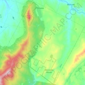
Nome: Mappa topografica Elmore, altitudine, rilievo.
Luogo: Elmore, Lamoille County, Vermont, 05657, United States (44.42398 -72.59728 44.55341 -72.42981)
Altitudine media: 422 m
Altitudine minima: 188 m
Altitudine massima: 986 m
Elmore is in southeastern Lamoille County, bordered to the south and east by Washington County. A small portion of the town border on the east is with Caledonia County. According to the United States Census Bureau, the town has a total area of 39.7 square miles (102.7 km2), of which 39.1 square miles (101.3 km2) are land and 0.54 square miles (1.4 km2), or 1.38%, are water. Lake Elmore is in the northwest corner of the town, and drains north via Elmore Pond Brook toward the Lamoille River. Elmore village sits at the northern end of the lake. The Worcester Mountains are on the western side of the town. Mt. Elmore, at the northern end of the range, rises to an elevation of 2,608 feet (795 m) to the west of Lake Elmore.
Altre mappe topografiche
Clicca su una mappa per visualizzarne la topografia, l'altitudine e il rilievo.
Wolcott
United States > Vermont > Lamoille County
Wolcott, Lamoille County, Vermont, 05680, United States
Altitudine media: 354 m
Stowe
United States > Vermont > Lamoille County
Stowe, Lamoille County, Vermont, United States
Altitudine media: 436 m
Green Mountains
United States > Vermont > Lamoille County > Cambridge
Green Mountains, Cambridge, Lamoille County, Vermont, United States
Altitudine media: 529 m
Morristown
United States > Vermont > Lamoille County
Morristown, Lamoille County, Vermont, 05661, United States
Altitudine media: 365 m
Morrisville
United States > Vermont > Lamoille County > Morristown
Morrisville, Morristown, Lamoille County, Vermont, 05661, United States
Altitudine media: 219 m
Hyde Park
United States > Vermont > Lamoille County
Hyde Park, Lamoille County, Vermont, United States
Altitudine media: 311 m
Morses Mill
United States > Vermont > Lamoille County > Cambridge
Morses Mill, Cambridge, Lamoille County, Vermont, United States
Altitudine media: 480 m
Johnson
United States > Vermont > Lamoille County
Johnson, Lamoille County, Vermont, 05656, United States
Altitudine media: 366 m
Lamoille Union Lower Field North
United States > Vermont > Lamoille County > Hyde Park
Lamoille Union Lower Field North, Hyde Park, Lamoille County, Vermont, United States
Altitudine media: 208 m
Jeffersonville
United States > Vermont > Lamoille County
Jeffersonville, Cambridge, Lamoille County, Vermont, 05464, United States
Altitudine media: 188 m
Lower Village
United States > Vermont > Lamoille County > Stowe
Lower Village, Stowe, Lamoille County, Vermont, 05672, United States
Altitudine media: 264 m
Waterville
United States > Vermont > Lamoille County > Waterville
Waterville, Lamoille County, Vermont, 05492, United States
Altitudine media: 341 m
Cambridge
United States > Vermont > Lamoille County
Cambridge, Lamoille County, Vermont, United States
Altitudine media: 315 m
Eden
United States > Vermont > Lamoille County
Eden, Lamoille County, Vermont, United States
Altitudine media: 440 m