
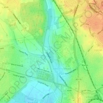
Mappa topografica Countess of Chester Country Park
Mappa interattiva
Clicca sulla mappa per visualizzare l'altitudine.
A proposito di questa mappa
Nome: Mappa topografica Countess of Chester Country Park, altitudine, rilievo.
Altitudine media: 21 m
Altitudine minima: 4 m
Altitudine massima: 39 m
Altre mappe topografiche
Clicca su una mappa per visualizzarne la topografia, l'altitudine e il rilievo.
Roman Fort
United Kingdom > England > Cheshire West and Chester > Chester
Roman Fort, Sandy Lane, Caldy Valley, Huntington, Chester, Cheshire West and Chester, North West England, England, CH3 6GS, United Kingdom
Altitudine media: 21 m
Chester Castle
United Kingdom > England > Cheshire West and Chester > Chester
Chester Castle, City Walls, Chester Castle, Chester, Cheshire West and Chester, North West England, England, CH1 1SG, United Kingdom
Altitudine media: 18 m
Poulton
United Kingdom > England > Cheshire West and Chester > Chester
Poulton, Poulton and Pulford, Chester, Cheshire West and Chester, England, CH4 9EE, United Kingdom
Altitudine media: 14 m