
Fai una donazione
Preparati per la tua prossima avventura:
In qualità di associato Amazon, questo sito riceve una commissione sugli acquisti idonei senza alcun costo aggiuntivo per te.
Mappa topografica Beryl
Clicca sulla mappa per visualizzare l'altitudine.
Fai una donazione
Preparati per la tua prossima avventura:
In qualità di associato Amazon, questo sito riceve una commissione sugli acquisti idonei senza alcun costo aggiuntivo per te.
A proposito di questa mappa
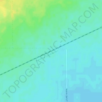
Nome: Mappa topografica Beryl, altitudine, rilievo.
Luogo: Beryl, Iron County, Utah, United States (37.87564 -113.68204 37.91564 -113.64204)
Altitudine media: 1.574 m
Altitudine minima: 1.566 m
Altitudine massima: 1.595 m
Fai una donazione
Preparati per la tua prossima avventura:
In qualità di associato Amazon, questo sito riceve una commissione sugli acquisti idonei senza alcun costo aggiuntivo per te.
Altre mappe topografiche
Clicca su una mappa per visualizzarne la topografia, l'altitudine e il rilievo.
Cedar City
United States > Utah > Iron County
Cedar City is located in the southeast Great Basin and is approximately 20 miles (32 km) north of the northeastern edge of the Mojave Desert. Its elevation of 5,846 feet (1,782 m) gives it a somewhat cooler climate compared to the nearby St. George region, though it retains cultural ties to the city —for…
Altitudine media: 1.975 m
Brian Head
United States > Utah > Iron County
The community, at an elevation of 9,800 feet (3,000 m) above sea level, is the highest town in Utah. It is located on State Route 143 and is east of Interstate 15. Brian Head is approximately three miles north of Cedar Breaks National Monument.
Altitudine media: 3.031 m
Modena
United States > Utah > Iron County
The settlement lies along State Route 56 west of the city of Parowan, the county seat of Iron County. Its elevation is 5,476 feet (1,669 m).
Altitudine media: 1.666 m
Cedar City
United States > Utah > Iron County
Cedar City is located in the southeast Great Basin and is approximately 20 miles (32 km) north of the northeastern edge of the Mojave Desert. Its elevation of 5,846 feet (1,782 m) gives it a somewhat cooler climate compared to the nearby St. George region, though it retains cultural ties to the city —for…
Altitudine media: 1.975 m
Fai una donazione
Preparati per la tua prossima avventura:
In qualità di associato Amazon, questo sito riceve una commissione sugli acquisti idonei senza alcun costo aggiuntivo per te.
Cedar City
United States > Utah > Iron County
Cedar City is located in the southeast Great Basin and is approximately 20 miles (32 km) north of the northeastern edge of the Mojave Desert. Its elevation of 5,846 feet (1,782 m) gives it a somewhat cooler climate compared to the nearby St. George region, though it retains cultural ties to the city. For…
Altitudine media: 1.975 m
Ashdown Gorge Wilderness
United States > Utah > Iron County
The wilderness is within the Dixie National Forest adjacent to Cedar Breaks National Monument and characterized by extremely steep-walled canyons cut through the west rim of the Markagunt Plateau. Elevations in the wilderness range from 10,500 feet (3,200 m) to 7,500 feet (2,300 m). Rattlesnake Creek and…
Altitudine media: 2.715 m
Fai una donazione
Preparati per la tua prossima avventura:
In qualità di associato Amazon, questo sito riceve una commissione sugli acquisti idonei senza alcun costo aggiuntivo per te.
Cedar City
United States > Utah > Iron County
Cedar City is located in the southeast Great Basin and is approximately 20 miles (32 km) north of the northeastern edge of the Mojave Desert. Its elevation of 5,846 feet (1,782 m) gives it a somewhat cooler climate compared to the nearby St. George region, though it retains cultural ties to the city —for…
Altitudine media: 1.975 m
Cedar City
United States > Utah > Iron County
Cedar City is located in the southeast Great Basin and is approximately 20 miles (32 km) north of the northeastern edge of the Mojave Desert. Its elevation of 5,846 feet (1,782 m) gives it a somewhat cooler climate compared to the nearby St. George region, though it retains cultural ties to the city. For…
Altitudine media: 1.975 m
Brian Head
United States > Utah > Iron County > Brian Head
The community, at an elevation of 9,800 feet (3,000 m) above sea level, is the highest town in Utah. It is located on State Route 143 and is east of Interstate 15. Brian Head is approximately three miles north of Cedar Breaks National Monument.
Altitudine media: 3.031 m
Fai una donazione
Preparati per la tua prossima avventura:
In qualità di associato Amazon, questo sito riceve una commissione sugli acquisti idonei senza alcun costo aggiuntivo per te.