
Mappa topografica Kannur
Clicca sulla mappa per visualizzare l'altitudine.
Kannur
Kannur has an elevation of 1.02 metres or 3.3 feet along the coast of the Laccadive Sea, with a sandy coastal area. The city has an 8 kilometres (5.0 miles)-long seashore and a 3 kilometres (1.9 miles)-long beach at Payyambalam. Kannur is located north of Kozhikode, south of Kasargod and Mangalore, west of the Western Ghat regions of Kodagu and Wayanad, and east of the Laccadive Sea. Mappila Bay harbour at Ayikkara. On one side, there is St. Angelo Fort (built in 1505) and on the other side is Arakkal palace. Muzhappilangad Beach, the longest Drive-in Beach in Asia, is located in Kannur. Vayalapra Lake is near Madayi.
A proposito di questa mappa
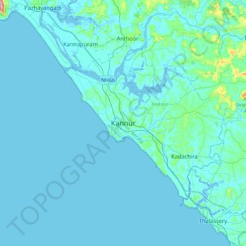
Nome: Mappa topografica Kannur, altitudine, rilievo.
Luogo: Kannur, Kerala, 670004, India (11.71638 75.21380 12.03638 75.53380)
Altitudine media: 13 m
Altitudine minima: -4 m
Altitudine massima: 225 m
Altre mappe topografiche
Clicca su una mappa per visualizzarne la topografia, l'altitudine e il rilievo.
Kannur
Kannur has an elevation of 1.02 metres or 3.3 feet along the coast of the Laccadive Sea, with a sandy coastal area. The city has an 8 kilometres (5.0 mi)-long seashore and a 3 kilometres (1.9 mi)-long beach at Payyambalam. Kannur is located north of Kozhikode, south of Kasargod and Mangalore, west of the…
Altitudine media: 14 m