
Fai una donazione
Preparati per la tua prossima avventura:
In qualità di associato Amazon, questo sito riceve una commissione sugli acquisti idonei senza alcun costo aggiuntivo per te.
Mappa topografica Leander
Clicca sulla mappa per visualizzare l'altitudine.
Fai una donazione
Preparati per la tua prossima avventura:
In qualità di associato Amazon, questo sito riceve una commissione sugli acquisti idonei senza alcun costo aggiuntivo per te.
A proposito di questa mappa
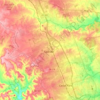
Nome: Mappa topografica Leander, altitudine, rilievo.
Luogo: Leander, Williamson County, Texas, United States (30.51141 -97.94604 30.64093 -97.76833)
Altitudine media: 297 m
Altitudine minima: 212 m
Altitudine massima: 357 m
Fai una donazione
Preparati per la tua prossima avventura:
In qualità di associato Amazon, questo sito riceve una commissione sugli acquisti idonei senza alcun costo aggiuntivo per te.
Altre mappe topografiche
Clicca su una mappa per visualizzarne la topografia, l'altitudine e il rilievo.
Soil Conservation Service Site 12 Dam
United States > Texas > Williamson County > Type
Altitudine media: 173 m
Soil Conservation Service Site 12 Dam
United States > Texas > Williamson County > Type
Altitudine media: 173 m
Georgetown
United States > Texas > Williamson County > Georgetown
The city is located on the northeastern edge of Texas Hill Country. Portions of Georgetown are located on either side of the Balcones Escarpment, a fault line in which the areas roughly east of IH-35 are flat and characterized by having black, fertile soils of the Blackland Prairie, and the west side of the…
Altitudine media: 228 m
Fai una donazione
Preparati per la tua prossima avventura:
In qualità di associato Amazon, questo sito riceve una commissione sugli acquisti idonei senza alcun costo aggiuntivo per te.
Soil Conservation Service Site 12 Dam
United States > Texas > Williamson County > Type
Altitudine media: 173 m
Round Rock
United States > Texas > Williamson County > Round Rock
The city straddles the Balcones Escarpment, a fault line in which the areas roughly east of Interstate 35 are flat and characterized by having black, fertile soils of the Blackland Prairie, and the west side of the Escarpment, which consists mostly of hilly, karst-like terrain with little topsoil and higher…
Altitudine media: 236 m