
Mappa topografica Gallipolis
Clicca sulla mappa per visualizzare l'altitudine.
Gallipolis
Winters are cold, with an average January temperature of 34.3 °F (1.3 °C). Snowfall is generally very light, with a mean average snowfall of 10.9 inches (280 mm). The village does not experience by lake-effect snow, although the village's weather can be influenced by the Great Lakes and regional topography. On average, there are 109 nights per year when the temperature drops to or below freezing, and only 14 days when the temperature fails to rise above freezing. Summers are hot and humid, with an average July temperature of 78.6 °F (25.9 °C). There are an average of 39 days per year with highs at or above 90 °F (32 °C).
A proposito di questa mappa
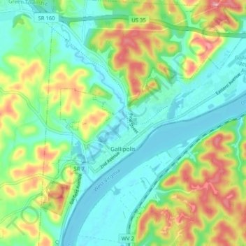
Nome: Mappa topografica Gallipolis, altitudine, rilievo.
Luogo: Gallipolis, Gallia County, Ohio, United States (38.79311 -82.22809 38.83919 -82.14937)
Altitudine media: 203 m
Altitudine minima: 165 m
Altitudine massima: 278 m
Altre mappe topografiche
Clicca su una mappa per visualizzarne la topografia, l'altitudine e il rilievo.