
Mappa topografica High Shincliffe
Clicca sulla mappa per visualizzare l'altitudine.
High Shincliffe
High Shincliffe is a village in County Durham, England. It is situated about two miles south-east of Durham City, on the A177 road to Stockton-on-Tees. The altitude of High Shincliffe is approximately 90 metres (300 ft), and it lies 55 metres (180 ft) above the River Wear at Shincliffe bridge. Latest population figures are available from the 2011 Census.
A proposito di questa mappa
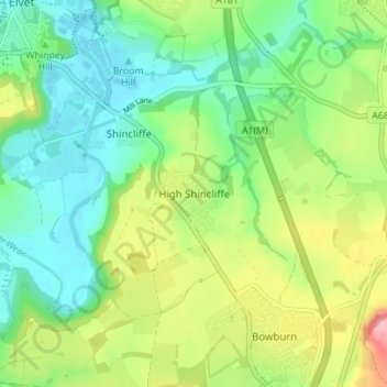
Nome: Mappa topografica High Shincliffe, altitudine, rilievo.
Altitudine media: 77 m
Altitudine minima: 32 m
Altitudine massima: 162 m
Altre mappe topografiche
Clicca su una mappa per visualizzarne la topografia, l'altitudine e il rilievo.
South Agnew Plantation
United Kingdom > England > County Durham > Newton Aycliffe
Altitudine media: 100 m
Great High Wood
United Kingdom > England > County Durham > Durham > High Shincliffe
Altitudine media: 63 m
Flass Vale Local Nature Reserve
United Kingdom > England > County Durham > Durham
Altitudine media: 81 m
Oakey's Park
United Kingdom > England > County Durham > Stanley > West Shield Row Villas
Altitudine media: 182 m
Bishop Middleham Quarry Nature Reserve
United Kingdom > England > County Durham > Bishop Middleham
Altitudine media: 115 m
Tunstall Reservoir
United Kingdom > England > County Durham > Wolsingham
The reservoir was created for the Weardale and Shildon District Waterworks Company, with construction of the dam between 1873 and 1879.[2][3] The earth embankment dam was built across the valley of Waskerley Beck, and measures 1,020 feet (310 m) long and 82 feet (25 m) high. It was constructed with a puddle…
Altitudine media: 288 m