
Mappa topografica Newbury
Mappa interattiva
Clicca sulla mappa per visualizzare l'altitudine.
A proposito di questa mappa
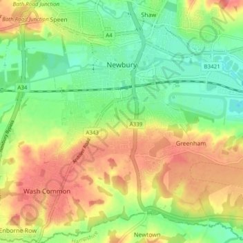
Nome: Mappa topografica Newbury, altitudine, rilievo.
Luogo: Newbury, West Berkshire, England, United Kingdom (51.36711 -1.35315 51.41456 -1.28819)
Altitudine media: 97 m
Altitudine minima: 64 m
Altitudine massima: 135 m
Elevations vary from a minimum of 72 m above mean sea level to 122 m at Wash Common. Elevations reach 150–200 m in the directly adjoining hills. The River Kennet and the Kennet and Avon Canal flow east through the centre of the town to reach the Thames at Reading, while the River Lambourn (beside which is the country's largest horse-training paddocks in the Valley of the Lambourn Downs) partly forms its northern boundary, ending in the town. A tributary that is smaller still, the River Enborne, forms the southern boundary (and also the county boundary with Hampshire).
Altre mappe topografiche
Clicca su una mappa per visualizzarne la topografia, l'altitudine e il rilievo.
Combe
United Kingdom > England > West Berkshire
Combe, West Berkshire, England, United Kingdom
Altitudine media: 215 m
Berkshire
United Kingdom > England > West Berkshire
Berkshire, West Berkshire, England, United Kingdom
Altitudine media: 100 m
Winterbourne
United Kingdom > England > West Berkshire
Winterbourne, West Berkshire, England, United Kingdom
Altitudine media: 120 m
Reading
United Kingdom > England > West Berkshire > Reading
Reading, West Berkshire, South East England, England, RG1 1DA, United Kingdom
Altitudine media: 56 m
Mortimer
United Kingdom > England > West Berkshire > Mortimer
Mortimer, Stratfield Mortimer, West Berkshire, South East England, England, RG7 3RD, United Kingdom
Altitudine media: 80 m