
Fai una donazione
Preparati per la tua prossima avventura:
In qualità di associato Amazon, questo sito riceve una commissione sugli acquisti idonei senza alcun costo aggiuntivo per te.
Mappa topografica Alcorcón
Clicca sulla mappa per visualizzare l'altitudine.
Fai una donazione
Preparati per la tua prossima avventura:
In qualità di associato Amazon, questo sito riceve una commissione sugli acquisti idonei senza alcun costo aggiuntivo per te.
Alcorcón
The municipality, largely flat, lies at an average altitude of 711 metres above sea level, with the highest point being El Ventorro del Cano (741 m), located in the north of the municipality.
Fai una donazione
Preparati per la tua prossima avventura:
In qualità di associato Amazon, questo sito riceve una commissione sugli acquisti idonei senza alcun costo aggiuntivo per te.
A proposito di questa mappa
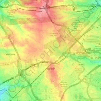
Nome: Mappa topografica Alcorcón, altitudine, rilievo.
Luogo: Alcorcón, Community of Madrid, Spain (40.32394 -3.87879 40.40310 -3.78790)
Altitudine media: 692 m
Altitudine minima: 634 m
Altitudine massima: 742 m
Fai una donazione
Preparati per la tua prossima avventura:
In qualità di associato Amazon, questo sito riceve una commissione sugli acquisti idonei senza alcun costo aggiuntivo per te.
Altre mappe topografiche
Clicca su una mappa per visualizzarne la topografia, l'altitudine e il rilievo.
Sierra de Guadarrama
The range runs southwest–northeast, extending from the province of Ávila in the southwest, through the Community of Madrid, to the province of Segovia in the northeast. The range measures approximately 80 kilometres (50 mi) in length. Its highest peak is Peñalara, 2,428 metres (7,966 ft) in elevation.
Altitudine media: 1.235 m
Fai una donazione
Preparati per la tua prossima avventura:
In qualità di associato Amazon, questo sito riceve una commissione sugli acquisti idonei senza alcun costo aggiuntivo per te.
La Maliciosa
Spain > Community of Madrid > Navacerrada
La Maliciosa is one of the most important and highest mountains of the Sierra de Guadarrama, a mountainous formation belonging to the Sistema Central. It has an altitude of 2227m above sea level and is located in the northwest of the Community of Madrid, in Spain, rising between La Pedriza, which lies to the…
Altitudine media: 1.856 m
Fai una donazione
Preparati per la tua prossima avventura:
In qualità di associato Amazon, questo sito riceve una commissione sugli acquisti idonei senza alcun costo aggiuntivo per te.
Fuenlabrada
Spain > Community of Madrid > Área metropolitana de Madrid y Corredor del Henares > Fuenlabrada
The founding of the village of Fuenlabrada has been tentatively traced to the late 14th century, populated by the dwellers of the nearby settlements of Loranca, Albas and Fregacedos, which had been simultaneously depopulated. The first mention of Fuenlabrada, which by the early 16th century was part of the…
Altitudine media: 630 m
Fai una donazione
Preparati per la tua prossima avventura:
In qualità di associato Amazon, questo sito riceve una commissione sugli acquisti idonei senza alcun costo aggiuntivo per te.
Loma del Rellano
Spain > Community of Madrid > Área metropolitana de Madrid y Corredor del Henares > San Sebastián de los Reyes
Altitudine media: 687 m