
Fai una donazione
Preparati per la tua prossima avventura:
In qualità di associato Amazon, questo sito riceve una commissione sugli acquisti idonei senza alcun costo aggiuntivo per te.
Mappa topografica Moses Coulee
Clicca sulla mappa per visualizzare l'altitudine.
Fai una donazione
Preparati per la tua prossima avventura:
In qualità di associato Amazon, questo sito riceve una commissione sugli acquisti idonei senza alcun costo aggiuntivo per te.
Moses Coulee
Pleistocene glaciers advanced onto the Waterville Plateau, with the Okanogan Lobe of the Cordilleran Ice Sheet reaching as far south as the town of Withrow. Evidence for glaciation on the Waterville Plateau includes polished and striated bedrock, glacial erratics, drumlinoid topography, eskers, moraines, meltwater channels, and glacial till. The Withrow Moraine complex marks the maximum southern extent of the Okanogan Lobe, and a series of recessional moraine complexes represent retreating ice margins. Ice damming of the Columbia River formed Glacial Lake Columbia and Lake Spokane, larger lakes than Lake Roosevelt, which is currently backed up in the same location behind the Grand Coulee Dam.
Fai una donazione
Preparati per la tua prossima avventura:
In qualità di associato Amazon, questo sito riceve una commissione sugli acquisti idonei senza alcun costo aggiuntivo per te.
A proposito di questa mappa
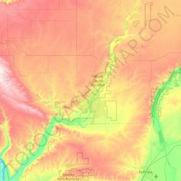
Nome: Mappa topografica Moses Coulee, altitudine, rilievo.
Luogo: Moses Coulee, Douglas County, Washington, United States (47.29413 -120.05919 47.75165 -119.58129)
Altitudine media: 666 m
Altitudine minima: 172 m
Altitudine massima: 1.219 m
Fai una donazione
Preparati per la tua prossima avventura:
In qualità di associato Amazon, questo sito riceve una commissione sugli acquisti idonei senza alcun costo aggiuntivo per te.
Altre mappe topografiche
Clicca su una mappa per visualizzarne la topografia, l'altitudine e il rilievo.
Waterville
United States > Washington > Douglas County
At 2,625 ft (800 m), Waterville has the highest elevation of any incorporated city or town in Washington.
Altitudine media: 807 m
Fai una donazione
Preparati per la tua prossima avventura:
In qualità di associato Amazon, questo sito riceve una commissione sugli acquisti idonei senza alcun costo aggiuntivo per te.
Fai una donazione
Preparati per la tua prossima avventura:
In qualità di associato Amazon, questo sito riceve una commissione sugli acquisti idonei senza alcun costo aggiuntivo per te.
Fai una donazione
Preparati per la tua prossima avventura:
In qualità di associato Amazon, questo sito riceve una commissione sugli acquisti idonei senza alcun costo aggiuntivo per te.