
Fai una donazione
Preparati per la tua prossima avventura:
In qualità di associato Amazon, questo sito riceve una commissione sugli acquisti idonei senza alcun costo aggiuntivo per te.
Mappa topografica Tomintoul
Clicca sulla mappa per visualizzare l'altitudine.
Fai una donazione
Preparati per la tua prossima avventura:
In qualità di associato Amazon, questo sito riceve una commissione sugli acquisti idonei senza alcun costo aggiuntivo per te.
Tomintoul
Tomintoul has an oceanic climate (Cfb), bordering on subpolar oceanic (Cfc). Tomintoul does not have an official MetOffice weather station, and the temperature values below are simulated. Due to the villages' location northeast of the Cairngorms massif, it is exposed to many snow-bearing wind directions; this is consolidated by its elevation of 345m above sea level and its latitude at 57°N. As a result, Tomintoul is one of the coldest and snowiest settlements in the UK.
Fai una donazione
Preparati per la tua prossima avventura:
In qualità di associato Amazon, questo sito riceve una commissione sugli acquisti idonei senza alcun costo aggiuntivo per te.
A proposito di questa mappa
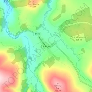
Nome: Mappa topografica Tomintoul, altitudine, rilievo.
Luogo: Tomintoul, Moray, Scotland, AB37 9ET, United Kingdom (57.23193 -3.39932 57.27193 -3.35932)
Altitudine media: 374 m
Altitudine minima: 274 m
Altitudine massima: 546 m
Fai una donazione
Preparati per la tua prossima avventura:
In qualità di associato Amazon, questo sito riceve una commissione sugli acquisti idonei senza alcun costo aggiuntivo per te.
Altre mappe topografiche
Clicca su una mappa per visualizzarne la topografia, l'altitudine e il rilievo.
Fochabers
United Kingdom > Scotland > Moray
The present village owes its existence to Alexander Gordon, 4th Duke of Gordon (1743–1827). During the late eighteenth century, during the Scottish Enlightenment, it was fashionable for landowners to found new towns and villages; these can be recognised all over Scotland, because unlike their predecessors…
Altitudine media: 59 m
Fai una donazione
Preparati per la tua prossima avventura:
In qualità di associato Amazon, questo sito riceve una commissione sugli acquisti idonei senza alcun costo aggiuntivo per te.
Fai una donazione
Preparati per la tua prossima avventura:
In qualità di associato Amazon, questo sito riceve una commissione sugli acquisti idonei senza alcun costo aggiuntivo per te.