
Mappa topografica Mount Marcy
Mappa interattiva
Clicca sulla mappa per visualizzare l'altitudine.
A proposito di questa mappa
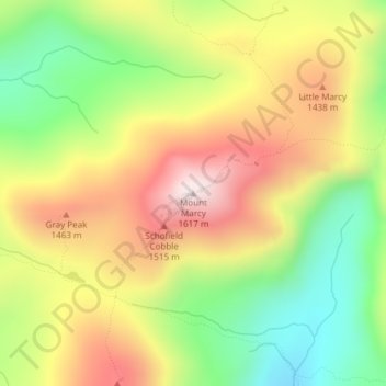
Nome: Mappa topografica Mount Marcy, altitudine, rilievo.
Altitudine media: 1.289 m
Altitudine minima: 985 m
Altitudine massima: 1.615 m
Mount Marcy (Mohawk: Tewawe’éstha) is the highest point in New York, with an elevation of 5,343.1 feet (1,628.6 m). It is located in the Town of Keene in Essex County. The mountain is in the heart of the Adirondack High Peaks region of the High Peaks Wilderness Area. Its stature and expansive views make it a popular destination for hikers, who crowd its summit in the summer months.
Altre mappe topografiche
Clicca su una mappa per visualizzarne la topografia, l'altitudine e il rilievo.
Keene Valley
United States > New York > Essex County > Town of Keene
Keene Valley, Town of Keene, Essex County, New York, 12943, United States
Altitudine media: 459 m
Saint Huberts
United States > New York > Essex County > Town of Keene
Saint Huberts, Town of Keene, Essex County, New York, 12943, United States
Altitudine media: 536 m
Glenmore
United States > New York > Essex County > Town of Keene
Glenmore, Town of Keene, Essex County, New York, 12942, United States
Altitudine media: 648 m
Giant Mountain
United States > New York > Essex County > Town of Keene
Giant Mountain, Town of Keene, Essex County, New York, United States
Altitudine media: 1.060 m
Gothics
United States > New York > Essex County > Town of Keene
Gothics, Town of Keene, Essex County, New York, United States
Altitudine media: 1.095 m