
Fai una donazione
Preparati per la tua prossima avventura:
In qualità di associato Amazon, questo sito riceve una commissione sugli acquisti idonei senza alcun costo aggiuntivo per te.
Mappa topografica Ponta Grossa
Clicca sulla mappa per visualizzare l'altitudine.
Fai una donazione
Preparati per la tua prossima avventura:
In qualità di associato Amazon, questo sito riceve una commissione sugli acquisti idonei senza alcun costo aggiuntivo per te.
Ponta Grossa
Ponta Grossa was founded on the farm of Miguel da Rocha Ferreira Carvalhaes who chose it as favorable agricultural land. The farm still exists towards Castro. In 1871 the city came to be called Pitangui, but the following year it resumed its original name. Sometimes it is the target of malicious humor due to what its name can send like in Portuguese. One way or another describes the characteristics of the vegetation and the regional topography.
Fai una donazione
Preparati per la tua prossima avventura:
In qualità di associato Amazon, questo sito riceve una commissione sugli acquisti idonei senza alcun costo aggiuntivo per te.
A proposito di questa mappa
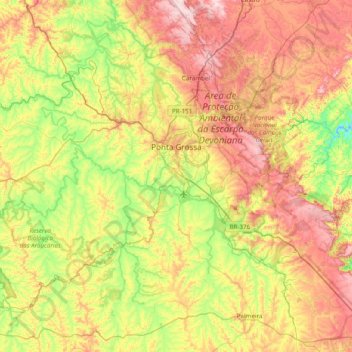
Nome: Mappa topografica Ponta Grossa, altitudine, rilievo.
Altitudine media: 893 m
Altitudine minima: 664 m
Altitudine massima: 1.215 m
Fai una donazione
Preparati per la tua prossima avventura:
In qualità di associato Amazon, questo sito riceve una commissione sugli acquisti idonei senza alcun costo aggiuntivo per te.