
Fai una donazione
Preparati per la tua prossima avventura:
In qualità di associato Amazon, questo sito riceve una commissione sugli acquisti idonei senza alcun costo aggiuntivo per te.
Mappa topografica Mount Cook
Clicca sulla mappa per visualizzare l'altitudine.
Fai una donazione
Preparati per la tua prossima avventura:
In qualità di associato Amazon, questo sito riceve una commissione sugli acquisti idonei senza alcun costo aggiuntivo per te.
Mount Cook
Temperatures at the mountain's base in the Hooker Valley around 800 metres (2,600 feet) range from −13 °C (9 °F) to 32 °C (90 °F), and generally fall just over 1 °C for every 200 metres of altitude.
Fai una donazione
Preparati per la tua prossima avventura:
In qualità di associato Amazon, questo sito riceve una commissione sugli acquisti idonei senza alcun costo aggiuntivo per te.
A proposito di questa mappa
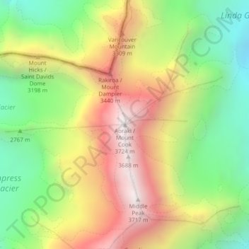
Nome: Mappa topografica Mount Cook, altitudine, rilievo.
Luogo: Mount Cook, Mackenzie District, Canterbury, New Zealand (-43.59505 170.14212 -43.59495 170.14222)
Altitudine media: 2.920 m
Altitudine minima: 2.235 m
Altitudine massima: 3.709 m
Fai una donazione
Preparati per la tua prossima avventura:
In qualità di associato Amazon, questo sito riceve una commissione sugli acquisti idonei senza alcun costo aggiuntivo per te.
Altre mappe topografiche
Clicca su una mappa per visualizzarne la topografia, l'altitudine e il rilievo.
Fai una donazione
Preparati per la tua prossima avventura:
In qualità di associato Amazon, questo sito riceve una commissione sugli acquisti idonei senza alcun costo aggiuntivo per te.
Tasman Glacier
New Zealand > Canterbury > Mackenzie District
At 23.5 kilometres (14.6 mi) in length, Tasman Glacier is still New Zealand's longest glacier, despite shrinking considerably from the 1990s onwards. It is as much as 4 kilometres (2.5 mi) wide and 600 metres (2,000 ft) thick, and lies entirely within the borders of Aoraki / Mount Cook National Park. The…
Altitudine media: 1.884 m
Fai una donazione
Preparati per la tua prossima avventura:
In qualità di associato Amazon, questo sito riceve una commissione sugli acquisti idonei senza alcun costo aggiuntivo per te.
Fai una donazione
Preparati per la tua prossima avventura:
In qualità di associato Amazon, questo sito riceve una commissione sugli acquisti idonei senza alcun costo aggiuntivo per te.
Fai una donazione
Preparati per la tua prossima avventura:
In qualità di associato Amazon, questo sito riceve una commissione sugli acquisti idonei senza alcun costo aggiuntivo per te.
Fai una donazione
Preparati per la tua prossima avventura:
In qualità di associato Amazon, questo sito riceve una commissione sugli acquisti idonei senza alcun costo aggiuntivo per te.
Fai una donazione
Preparati per la tua prossima avventura:
In qualità di associato Amazon, questo sito riceve una commissione sugli acquisti idonei senza alcun costo aggiuntivo per te.
Aoraki / Mount Cook National Park
New Zealand > Canterbury > Mackenzie District
Temperatures in Mount Cook Village range between extremes of −13 °C (9 °F) to 32 °C (90 °F), and typically fall just over 1 °C (34 °F) for every 200 metres (660 ft) of additional altitude.
Altitudine media: 1.386 m
Aoraki / Mount Cook National Park
New Zealand > Canterbury > Mackenzie District
Temperatures in Mount Cook Village range between extremes of −13 °C (9 °F) to 32 °C (90 °F), and typically fall just over 1 °C (34 °F) for every 200 metres (660 ft) of additional altitude.
Altitudine media: 1.386 m
Fai una donazione
Preparati per la tua prossima avventura:
In qualità di associato Amazon, questo sito riceve una commissione sugli acquisti idonei senza alcun costo aggiuntivo per te.
Tasman Glacier
New Zealand > Canterbury > Mackenzie District
At 23.5 kilometres (14.6 mi) in length, Tasman Glacier is still New Zealand's longest glacier, despite shrinking considerably from the 1990s onwards. It is as much as 4 kilometres (2.5 mi) wide and 600 metres (2,000 ft) thick, and lies entirely within the borders of Aoraki / Mount Cook National Park. The…
Altitudine media: 1.884 m
Lake Tekapo
New Zealand > Canterbury > Mackenzie District
Lake Tekapo (Māori: Takapō) is the second-largest of three roughly parallel lakes running north–south along the northern edge of the Mackenzie Basin in the South Island of New Zealand (the others are Lake Pukaki and Lake Ōhau). It covers an area of 83 square kilometres (32 sq mi) and is at an altitude of…
Altitudine media: 1.025 m
Fai una donazione
Preparati per la tua prossima avventura:
In qualità di associato Amazon, questo sito riceve una commissione sugli acquisti idonei senza alcun costo aggiuntivo per te.