
Mappa topografica Ridgeway
Clicca sulla mappa per visualizzare l'altitudine.
A proposito di questa mappa
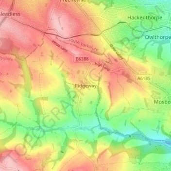
Nome: Mappa topografica Ridgeway, altitudine, rilievo.
Altitudine media: 136 m
Altitudine minima: 53 m
Altitudine massima: 211 m
Altre mappe topografiche
Clicca su una mappa per visualizzarne la topografia, l'altitudine e il rilievo.
Ogston Reservoir
United Kingdom > England > Derbyshire > North East Derbyshire > Woolley Moor
Altitudine media: 137 m
Doghole Wood
United Kingdom > England > Derbyshire > North East Derbyshire > Holymoorside
Altitudine media: 142 m
Dronfield Nature Park
United Kingdom > England > Derbyshire > North East Derbyshire > Dronfield > Unstone Green
Altitudine media: 156 m
Ashover CP
United Kingdom > England > Derbyshire > North East Derbyshire
By the 18th century, there were several thousand acres of unenclosed moorland in the parish of Ashover, principally covered with heath. The only paths across this wilderness for roads were tracks in the sand or heath with here and there a stone post on the hills or elevations to serve as guides to the…
Altitudine media: 210 m
Norwood Cottage Lakes
United Kingdom > England > Derbyshire > North East Derbyshire > Killamarsh
Altitudine media: 93 m
Grassmoor Country Park
United Kingdom > England > Derbyshire > North East Derbyshire > Corbriggs
Altitudine media: 116 m
Holmesfield
United Kingdom > England > Derbyshire > North East Derbyshire > Holmesfield
Altitudine media: 233 m