
Mappa topografica Manchester
Mappa interattiva
Clicca sulla mappa per visualizzare l'altitudine.
Manchester
According to the United States Census Bureau, the city has a total area of 35.0 square miles (90.6 km2), of which 33.1 square miles (85.7 km2) are land and 1.9 square miles (4.8 km2) are water, comprising 5.33% of the city. Manchester is drained by the Merrimack River and its tributaries the Piscataquog River and Cohas Brook. Massabesic Lake is on the eastern border. The highest point in Manchester is atop Wellington Hill, where the elevation reaches 570 feet (170 m) above sea level.
A proposito di questa mappa
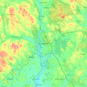
Nome: Mappa topografica Manchester, altitudine, rilievo.
Altitudine media: 126 m
Altitudine minima: 28 m
Altitudine massima: 400 m
Altre mappe topografiche
Clicca su una mappa per visualizzarne la topografia, l'altitudine e il rilievo.
Massabesic Lake
United States > New Hampshire > Hillsborough County > Manchester
Altitudine media: 90 m