
Fai una donazione
Preparati per la tua prossima avventura:
In qualità di associato Amazon, questo sito riceve una commissione sugli acquisti idonei senza alcun costo aggiuntivo per te.
Mappa topografica Mount Angel
Clicca sulla mappa per visualizzare l'altitudine.
Fai una donazione
Preparati per la tua prossima avventura:
In qualità di associato Amazon, questo sito riceve una commissione sugli acquisti idonei senza alcun costo aggiuntivo per te.
Mount Angel
Rev. Fr. Adelhelm Odermatt, O.S.B., came to Oregon in 1881 with a contingent of Benedictine monks from Engelberg, Switzerland, in order to establish a new American daughter house. After visiting several locations, he found Lone Butte to be the ideal location for a new abbey, and shortly afterwards ministered to several local Roman Catholic parishes, about the same time large numbers of immigrants from Bavaria settled in the area. Due to his efforts, the city, post office and the nearby elevation Lone Butte came to be known as Mount Angel (an English translation of Engelberg) in 1883. He also established Mount Angel Abbey, a Benedictine monastery and school, which was moved permanently to Mt. Angel in 1884.
Fai una donazione
Preparati per la tua prossima avventura:
In qualità di associato Amazon, questo sito riceve una commissione sugli acquisti idonei senza alcun costo aggiuntivo per te.
A proposito di questa mappa
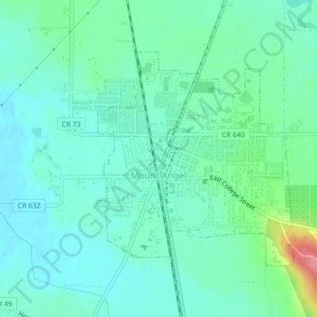
Nome: Mappa topografica Mount Angel, altitudine, rilievo.
Luogo: Mount Angel, Marion County, Oregon, United States (45.06008 -122.80715 45.07834 -122.78338)
Altitudine media: 58 m
Altitudine minima: 36 m
Altitudine massima: 134 m
Fai una donazione
Preparati per la tua prossima avventura:
In qualità di associato Amazon, questo sito riceve una commissione sugli acquisti idonei senza alcun costo aggiuntivo per te.