
Fai una donazione
Preparati per la tua prossima avventura:
In qualità di associato Amazon, questo sito riceve una commissione sugli acquisti idonei senza alcun costo aggiuntivo per te.
Mappa topografica Nimpo Lake
Clicca sulla mappa per visualizzare l'altitudine.
Fai una donazione
Preparati per la tua prossima avventura:
In qualità di associato Amazon, questo sito riceve una commissione sugli acquisti idonei senza alcun costo aggiuntivo per te.
A proposito di questa mappa
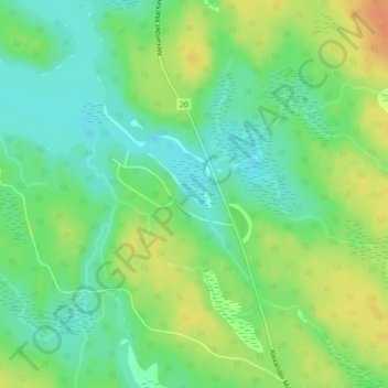
Nome: Mappa topografica Nimpo Lake, altitudine, rilievo.
Altitudine media: 1.131 m
Altitudine minima: 1.115 m
Altitudine massima: 1.151 m
Fai una donazione
Preparati per la tua prossima avventura:
In qualità di associato Amazon, questo sito riceve una commissione sugli acquisti idonei senza alcun costo aggiuntivo per te.
Altre mappe topografiche
Clicca su una mappa per visualizzarne la topografia, l'altitudine e il rilievo.
Mount Juno
Canada > British Columbia > Cariboo Regional District > Area J (West Chilcotin)
Altitudine media: 2.219 m
Anahim Lake
Canada > British Columbia > Cariboo Regional District > Area J (West Chilcotin)
Altitudine media: 1.101 m
Nimpo Lake
Canada > British Columbia > Cariboo Regional District > Area J (West Chilcotin)
Nimpo Lake is the jumping off point to the wilderness, much of it inaccessible to people except by floatplane or on foot. You can go flightseeing over Hunlen Falls, the third longest freefalling waterfall in Canada, or fly over the multicolored Rainbow Mountains or Monarch Mountain and see the pristine…
Altitudine media: 1.150 m
Heckman Pass
Canada > British Columbia > Cariboo Regional District > Area J (West Chilcotin)
Altitudine media: 1.519 m
Fai una donazione
Preparati per la tua prossima avventura:
In qualità di associato Amazon, questo sito riceve una commissione sugli acquisti idonei senza alcun costo aggiuntivo per te.
Tŝilhqox Biny (Chilko Lake)
Canada > British Columbia > Cariboo Regional District > Area J (West Chilcotin)
Tŝilhqox Biny (Pronounced: Tsyle-koh Bee), known as Chilko Lake, is a 180 km2 lake in west-central British Columbia, at the head of the Chilko River on the Chilcotin Plateau. The lake is about 65 km long, with a southwest arm 10 km long. It is one of the largest lakes by volume in the province because of its…
Altitudine media: 1.739 m
Itcha Range
Canada > British Columbia > Cariboo Regional District > Area J (West Chilcotin)
Altitudine media: 1.747 m
Ilgachuz Range
Canada > British Columbia > Cariboo Regional District > Area J (West Chilcotin)
The Ilgachuz Range is a name given to an extinct shield volcano in British Columbia, Canada. It is not a mountain range in the normal sense, because it was formed as a single volcano that has been eroded for the past five million years. It lies on the Chilcotin Plateau, located some 350 kilometres (220 mi)…
Altitudine media: 2.018 m
Rainbow Range
Canada > British Columbia > Cariboo Regional District > Area J (West Chilcotin)
Altitudine media: 1.741 m
Fai una donazione
Preparati per la tua prossima avventura:
In qualità di associato Amazon, questo sito riceve una commissione sugli acquisti idonei senza alcun costo aggiuntivo per te.
Tatla Lake
Canada > British Columbia > Cariboo Regional District > Area J (West Chilcotin)
Altitudine media: 1.080 m
Anahim Peak
Canada > British Columbia > Cariboo Regional District > Area J (West Chilcotin)
Altitudine media: 1.416 m
Puntzi Mountain
Canada > British Columbia > Cariboo Regional District > Area J (West Chilcotin)
Altitudine media: 1.293 m
The Joker
Canada > British Columbia > Cariboo Regional District > Area J (West Chilcotin)
Altitudine media: 2.157 m
Fai una donazione
Preparati per la tua prossima avventura:
In qualità di associato Amazon, questo sito riceve una commissione sugli acquisti idonei senza alcun costo aggiuntivo per te.
Tŝilhqox Biny (Chilko Lake)
Canada > British Columbia > Cariboo Regional District > Area J (West Chilcotin)
Tŝilhqox Biny (Pronounced: Tsyle-koh Bee), known as Chilko Lake, is a 180 km2 lake in west-central British Columbia, at the head of the Chilko River on the Chilcotin Plateau. The lake is about 65 km long, with a southwest arm 10 km long. It is one of the largest lakes by volume in the province because of its…
Altitudine media: 1.739 m