
Fai una donazione
Preparati per la tua prossima avventura:
In qualità di associato Amazon, questo sito riceve una commissione sugli acquisti idonei senza alcun costo aggiuntivo per te.
Mappa topografica Parleys Canyon
Clicca sulla mappa per visualizzare l'altitudine.
Fai una donazione
Preparati per la tua prossima avventura:
In qualità di associato Amazon, questo sito riceve una commissione sugli acquisti idonei senza alcun costo aggiuntivo per te.
Parleys Canyon
Parleys Canyon is a canyon located in the U.S. state of Utah. The canyon provides the route of Interstate 80 (I-80) (and previously the Lincoln Highway, U.S. Route 40, and a railroad) up the western slope of the Wasatch Mountains and is a relatively wide, straight canyon other than near its mouth. The mountain pass at the top of the canyon is known as Parleys Summit. With an elevation of 7,120 feet (2,170 m), the pass is the highest point along I-80 in the state of Utah. Both features are named for Parley P. Pratt, an early settler of the Salt Lake Valley and leader of the Church of Jesus Christ of Latter-day Saints who surveyed the area to find a better transportation route through the Wasatch Mountains than the previous route which traversed Emigration Canyon.
Fai una donazione
Preparati per la tua prossima avventura:
In qualità di associato Amazon, questo sito riceve una commissione sugli acquisti idonei senza alcun costo aggiuntivo per te.
A proposito di questa mappa
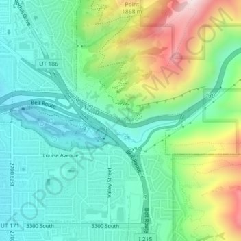
Nome: Mappa topografica Parleys Canyon, altitudine, rilievo.
Altitudine media: 1.577 m
Altitudine minima: 1.405 m
Altitudine massima: 1.984 m
Fai una donazione
Preparati per la tua prossima avventura:
In qualità di associato Amazon, questo sito riceve una commissione sugli acquisti idonei senza alcun costo aggiuntivo per te.