
Fai una donazione
Preparati per la tua prossima avventura:
In qualità di associato Amazon, questo sito riceve una commissione sugli acquisti idonei senza alcun costo aggiuntivo per te.
Mappa topografica Fall Creek Falls State Park
Clicca sulla mappa per visualizzare l'altitudine.
Fai una donazione
Preparati per la tua prossima avventura:
In qualità di associato Amazon, questo sito riceve una commissione sugli acquisti idonei senza alcun costo aggiuntivo per te.
Fall Creek Falls State Park
Just beyond its source, Cane Creek slowly gains strength as it absorbs Meadow Creek and several smaller streams. As the creek enters the gorge, it drops several hundred feet in less than a mile, including 45 feet (14 m) over Cane Creek Cascades and 85 feet (26 m) over Cane Creek Falls. A few hundred meters north of Cane Creek Falls, Rockhouse Creek spills 125 feet (38 m) over a plunge waterfall. Over the next half-mile, Cane Creek absorbs Fall Creek and Piney Creek, both of which enter from smaller gorges to the immediate west. During this stretch, part of the creek disappears underground into limestone sinks and reemerges at a spring known as "Crusher Hole." Cane Creek continues to lose elevation before steadying near its confluence with Dry Fork. Beyond Dry Fork, the creek gradually descends to the Highland Rim, where it empties into the Caney Fork River.
Fai una donazione
Preparati per la tua prossima avventura:
In qualità di associato Amazon, questo sito riceve una commissione sugli acquisti idonei senza alcun costo aggiuntivo per te.
A proposito di questa mappa
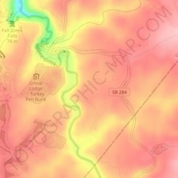
Nome: Mappa topografica Fall Creek Falls State Park, altitudine, rilievo.
Altitudine media: 524 m
Altitudine minima: 413 m
Altitudine massima: 564 m
Fai una donazione
Preparati per la tua prossima avventura:
In qualità di associato Amazon, questo sito riceve una commissione sugli acquisti idonei senza alcun costo aggiuntivo per te.