
Mappa topografica Tawang
Mappa interattiva
Clicca sulla mappa per visualizzare l'altitudine.
A proposito di questa mappa
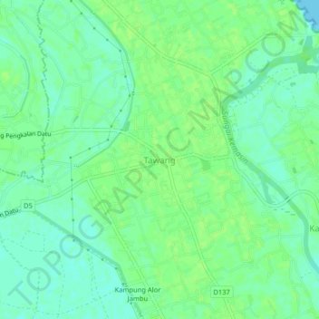
Nome: Mappa topografica Tawang, altitudine, rilievo.
Luogo: Tawang, Bachok, Kelantan, 16050, Malaysia (6.09511 102.32953 6.13511 102.36953)
Altitudine media: 7 m
Altitudine minima: 0 m
Altitudine massima: 11 m
Tawang is situated 448 km north-west of state capital Itanagar at an elevation of approximately 3,048 metres (10,000 ft). The town lies to the north of the Tawang Chu river valley, roughly 10 miles (16 km) south of the Line of Actual Control with China. The town once served as the district headquarters of West Kameng district. In 1989, the present day Tawang district to the north of the Sela Pass was split off as a separate district.