
Mappa topografica Ax-les-Thermes
Mappa interattiva
Clicca sulla mappa per visualizzare l'altitudine.
A proposito di questa mappa
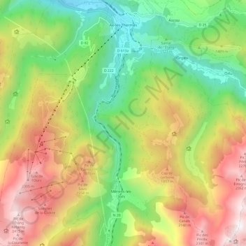
Nome: Mappa topografica Ax-les-Thermes, altitudine, rilievo.
Altitudine media: 1.449 m
Altitudine minima: 665 m
Altitudine massima: 2.473 m
Ax (from Latin Aquae – water; French Thermes – hot springs), situated at an elevation of 700 metres (2,300 ft), is well known for its sulphurous hot springs (25 to 78 °C or 77 to 172 °F). The waters, which were used by the Romans, were historically claimed to treat rheumatism, skin diseases, and other maladies. The springs were developed in the medieval period on the orders of Saint Louis to treat soldiers returning from the Crusades afflicted with leprosy. From the 19th century, a spa tourism industry developed.
Altre mappe topografiche
Clicca su una mappa per visualizzarne la topografia, l'altitudine e il rilievo.
Rufat
France > Occitania > Ariège > Ax-les-Thermes
Rufat, Ax-les-Thermes, Foix, Ariège, Occitania, Metropolitan France, 09110, France
Altitudine media: 994 m