
Fai una donazione
Preparati per la tua prossima avventura:
In qualità di associato Amazon, questo sito riceve una commissione sugli acquisti idonei senza alcun costo aggiuntivo per te.
Mappa topografica Kronstadt
Clicca sulla mappa per visualizzare l'altitudine.
Fai una donazione
Preparati per la tua prossima avventura:
In qualità di associato Amazon, questo sito riceve una commissione sugli acquisti idonei senza alcun costo aggiuntivo per te.
Kronstadt
The Kronstadt tide gauge is situated near the former Italian palace. Sea level observations in Saint Petersburg began already in 1703. On Kotlin Island, the main naval fortress of the Russian Empire began observations in 1707. This monitoring was necessary because the water level of the Finnish Gulf could change considerably in a short time, creating problems for shipping. The annual flood also required close monitoring of the water level. The Kronstadt sea-gauge with the tide gauge pavilion is the zero level of the Baltic system of highs and lows. All depths and altitudes (even the heights of spacecraft) in Russia and some other countries of the former Russian Empire are measured according to the Kronstadt sea-gauge. Yuri Gagarin, the first man in space, said in 1967 that it was "the Hub of the Universe".
Fai una donazione
Preparati per la tua prossima avventura:
In qualità di associato Amazon, questo sito riceve una commissione sugli acquisti idonei senza alcun costo aggiuntivo per te.
A proposito di questa mappa
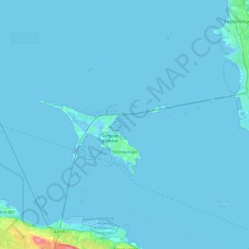
Nome: Mappa topografica Kronstadt, altitudine, rilievo.
Altitudine media: 2 m
Altitudine minima: -10 m
Altitudine massima: 73 m
Fai una donazione
Preparati per la tua prossima avventura:
In qualità di associato Amazon, questo sito riceve una commissione sugli acquisti idonei senza alcun costo aggiuntivo per te.
Altre mappe topografiche
Clicca su una mappa per visualizzarne la topografia, l'altitudine e il rilievo.
Saint Petersburg
Russia > Saint Petersburg > Saint Petersburg
The elevation of Saint Petersburg ranges from the sea level to its highest point of 175.9 m (577 ft) at the Orekhovaya Hill in the Duderhof Heights in the south. Part of the city's territory west of Liteyny Prospekt is no higher than 4 m (13 ft) above sea level, and has suffered from numerous floods. Floods in…
Altitudine media: 14 m