
Fai una donazione
Preparati per la tua prossima avventura:
In qualità di associato Amazon, questo sito riceve una commissione sugli acquisti idonei senza alcun costo aggiuntivo per te.
Mappa topografica Frisco
Clicca sulla mappa per visualizzare l'altitudine.
Fai una donazione
Preparati per la tua prossima avventura:
In qualità di associato Amazon, questo sito riceve una commissione sugli acquisti idonei senza alcun costo aggiuntivo per te.
Frisco
When the Dallas area was being settled by American pioneers, many of the settlers traveled by wagon trains along the Shawnee Trail. This trail became the Preston Trail, and later, Preston Road. With all of this activity, the community of Lebanon was founded along this trail, and was granted a U.S. post office in 1860. In 1902, a line of the St. Louis-San Francisco Railway was being built through the area, and periodic watering stops were needed along the route for the steam locomotives. The current settlement of Lebanon was on the Preston Ridge, and was too high in elevation, so the watering stop was placed about 4 miles (6 km) to the west on lower ground. A community grew around this train stop. Some residents of Lebanon actually moved their houses to the new community on logs. The new town was originally named Emerson, but the U.S. Postal Service rejected the name as being too similar to another town in Texas. In 1904, the town's residents chose "Frisco City" in honor of the St. Louis–San Francisco Railway. This name was later shortened to Frisco.
Fai una donazione
Preparati per la tua prossima avventura:
In qualità di associato Amazon, questo sito riceve una commissione sugli acquisti idonei senza alcun costo aggiuntivo per te.
A proposito di questa mappa
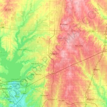
Nome: Mappa topografica Frisco, altitudine, rilievo.
Luogo: Frisco, Collin County, Texas, 75034, United States (32.99067 -96.98361 33.31067 -96.66361)
Altitudine media: 191 m
Altitudine minima: 133 m
Altitudine massima: 246 m
Fai una donazione
Preparati per la tua prossima avventura:
In qualità di associato Amazon, questo sito riceve una commissione sugli acquisti idonei senza alcun costo aggiuntivo per te.