
Fai una donazione
Preparati per la tua prossima avventura:
In qualità di associato Amazon, questo sito riceve una commissione sugli acquisti idonei senza alcun costo aggiuntivo per te.
Mappa topografica Krell Hill
Clicca sulla mappa per visualizzare l'altitudine.
Fai una donazione
Preparati per la tua prossima avventura:
In qualità di associato Amazon, questo sito riceve una commissione sugli acquisti idonei senza alcun costo aggiuntivo per te.
A proposito di questa mappa
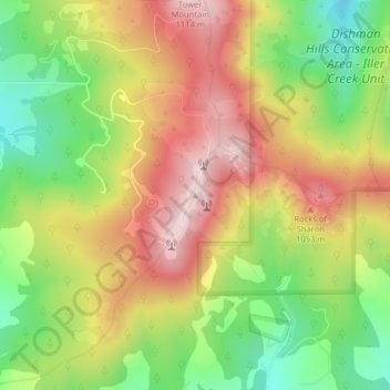
Nome: Mappa topografica Krell Hill, altitudine, rilievo.
Luogo: Krell Hill, Spokane County, Washington, United States (47.57922 -117.29807 47.57932 -117.29797)
Altitudine media: 958 m
Altitudine minima: 799 m
Altitudine massima: 1.114 m
Fai una donazione
Preparati per la tua prossima avventura:
In qualità di associato Amazon, questo sito riceve una commissione sugli acquisti idonei senza alcun costo aggiuntivo per te.
Altre mappe topografiche
Clicca su una mappa per visualizzarne la topografia, l'altitudine e il rilievo.
Millwood
United States > Washington > Spokane County
The topography of the city is mostly flat as it lies on the floor of the Spokane Valley, though it does slope gently down towards the north. The northern edge of town is defined by the Spokane River, where the terrain promptly drops about 20 feet down to the river bank.
Altitudine media: 600 m
Fai una donazione
Preparati per la tua prossima avventura:
In qualità di associato Amazon, questo sito riceve una commissione sugli acquisti idonei senza alcun costo aggiuntivo per te.
Riverside State Park
United States > Washington > Spokane County > Spokane
Terrain in park is varied, with steep valleys along the rivers and more flat plateaus above. The Spokane River falls from approximately 1,680 feet when it enters the park in the south to approximately 1,540 feet at the Long Lake Reservoir on the northern edge of the park. Surrounding plateaus rise to 2,200…
Altitudine media: 645 m