
Mappa topografica Burnley
Mappa interattiva
Clicca sulla mappa per visualizzare l'altitudine.
A proposito di questa mappa
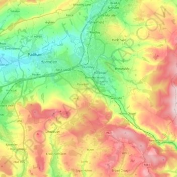
Nome: Mappa topografica Burnley, altitudine, rilievo.
Luogo: Burnley, Lancashire, England, United Kingdom (53.72300 -2.34231 53.82526 -2.11228)
Altitudine media: 247 m
Altitudine minima: 63 m
Altitudine massima: 479 m
The town lies in a natural three-forked valley at the confluence of the River Brun and the River Calder, surrounded by open fields, with wild moorland at higher altitudes. To the west of Burnley lie the towns of Padiham, Accrington and Blackburn, with Nelson and Colne to the north. The centre of the town stands at approximately 387 feet (118 m) above sea level and 30 miles (48 km) east of the Irish Sea coast.
Altre mappe topografiche
Clicca su una mappa per visualizzarne la topografia, l'altitudine e il rilievo.
Waddington
United Kingdom > England > Lancashire > Ribble Valley
Waddington, Ribble Valley, Lancashire, England, United Kingdom
Altitudine media: 164 m
Great Eccleston
United Kingdom > England > Lancashire > Borough of Wyre
Great Eccleston, Borough of Wyre, Lancashire, England, United Kingdom
Altitudine media: 12 m
Wymott
United Kingdom > England > Lancashire > Chorley
Wymott, Ulnes Walton, Chorley, Lancashire, England, PR26 8NH, United Kingdom
Altitudine media: 17 m
Croston
United Kingdom > England > Lancashire > Chorley
Croston, Chorley, Lancashire, England, United Kingdom
Altitudine media: 8 m
Fleetwood
United Kingdom > England > Lancashire > Borough of Wyre
Fleetwood, Borough of Wyre, Lancashire, England, United Kingdom
Altitudine media: 2 m
Leyland
United Kingdom > England > Lancashire > South Ribble
Leyland, South Ribble, Lancashire, England, PR25 2EX, United Kingdom
Altitudine media: 41 m
Read
United Kingdom > England > Lancashire > Ribble Valley
Read, Ribble Valley, Lancashire, England, United Kingdom
Altitudine media: 114 m
Lytham St Annes
United Kingdom > England > Lancashire > Fylde > Lytham St Annes
Lytham St Annes, Fylde, Lancashire, North West England, England, FY8 4AR, United Kingdom
Altitudine media: 5 m
Jamacia Wood
United Kingdom > England > Lancashire > Ribble Valley > Langho
Jamacia Wood, Billington and Langho, Langho, Ribble Valley, Lancashire, England, United Kingdom
Altitudine media: 100 m