
Fai una donazione
Preparati per la tua prossima avventura:
In qualità di associato Amazon, questo sito riceve una commissione sugli acquisti idonei senza alcun costo aggiuntivo per te.
Mappa topografica Kudremukha
Clicca sulla mappa per visualizzare l'altitudine.
Fai una donazione
Preparati per la tua prossima avventura:
In qualità di associato Amazon, questo sito riceve una commissione sugli acquisti idonei senza alcun costo aggiuntivo per te.
Kudremukha
The town of Kudremukha (KIOCL & etc.) lies at an elevation of around 815 metres (2,674 ft), whereas the peak stands at 1,894 metres (6,214 ft). The southern and western sides of the park form the steep slope of the Western Ghats ridgeline, with the altitude varying from 100 m - 1892 m (peak). The northern, central, and eastern portions of the park constitute a chain of rolling hills with a mosaic of natural grassland and shola forests. Kudremukha receives an average annual rainfall of 7000 mm, largely due to the forest types of mainly evergreen vegetation that can be found here.
Fai una donazione
Preparati per la tua prossima avventura:
In qualità di associato Amazon, questo sito riceve una commissione sugli acquisti idonei senza alcun costo aggiuntivo per te.
A proposito di questa mappa
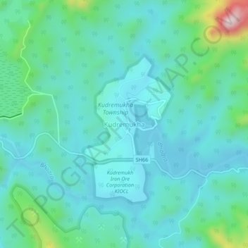
Nome: Mappa topografica Kudremukha, altitudine, rilievo.
Luogo: Kudremukha, Kalasa taluk, Chikkamagaluru, Karnataka, India (13.19907 75.23103 13.23907 75.27103)
Altitudine media: 858 m
Altitudine minima: 775 m
Altitudine massima: 1.239 m
Fai una donazione
Preparati per la tua prossima avventura:
In qualità di associato Amazon, questo sito riceve una commissione sugli acquisti idonei senza alcun costo aggiuntivo per te.