
Mappa topografica Bhubaneshwar
Clicca sulla mappa per visualizzare l'altitudine.
Bhubaneshwar
Bhubaneswar is in Khordha district of Odisha. It is in the eastern coastal plains, along the axis of the Eastern Ghats mountains. The city has an average altitude of 45 m (148 ft) above sea level. Bhubaneswar lies in Mahanadi River Delta. The Daya River is 4 km to the south and the Kuakhai River 4 km to the east; the Chandaka Wildlife Sanctuary and Nandankanan Zoo are in west and north to Bhubaneswar, respectively.
A proposito di questa mappa
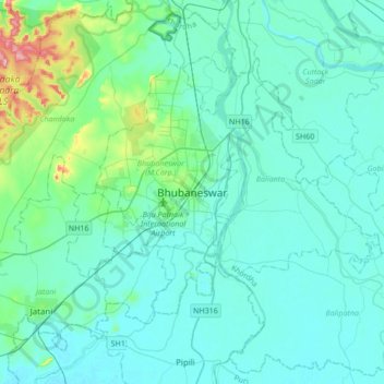
Nome: Mappa topografica Bhubaneshwar, altitudine, rilievo.
Altitudine media: 30 m
Altitudine minima: 6 m
Altitudine massima: 199 m
Altre mappe topografiche
Clicca su una mappa per visualizzarne la topografia, l'altitudine e il rilievo.
Ward 44
India > Odisha > Bhubaneswar (M.Corp.) > Bhubaneswar Municipal Corporation
Altitudine media: 21 m
Ward 43
India > Odisha > Bhubaneswar (M.Corp.) > Bhubaneswar Municipal Corporation
Altitudine media: 28 m
Netaji Subash chandra Bose Park
India > Odisha > Bhubaneswar (M.Corp.) > Bhubaneswar Municipal Corporation
Altitudine media: 34 m