
Mappa topografica Taunus
Clicca sulla mappa per visualizzare l'altitudine.
Taunus
Hintertaunus is the name given to the area north of the Hoher Taunus up to the Lahn valley. The landscape here is lower and less mountainous than in the southern Taunus. Between the valleys, some of which are quite deep, there are pronounced plateaus (leveled areas) with heavy agricultural use. Since mostly only the slopes of the valley are forested, the Hintertaunus is generally more open. The landscape of the Hintertaunus is more inconsistent because of its different elevations. This is clearly evident in the eastern Hintertaunus. Here, for example, there is a high-altitude landscape with dense forest cover, a harsher climate and poor soil in the Pferdskopf-Bergland; but also the Usinger basin, a gently undulating, open basin landscape with fertile soil and a balanced climate.
A proposito di questa mappa
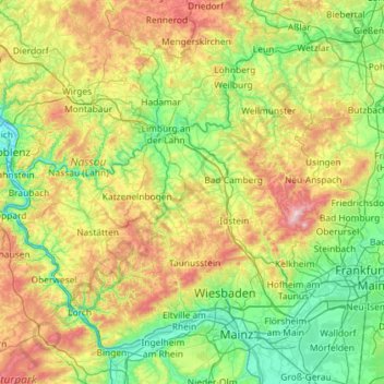
Nome: Mappa topografica Taunus, altitudine, rilievo.
Luogo: Taunus, Hesse, Germany (49.97429 7.57840 50.57366 8.73413)
Altitudine media: 280 m
Altitudine minima: 63 m
Altitudine massima: 874 m
Altre mappe topografiche
Clicca su una mappa per visualizzarne la topografia, l'altitudine e il rilievo.
Wiesbaden
The highest point of the Wiesbaden municipality is located northwest of the city center near the summit of the Hohe Wurzel, with an elevation of 608 metres (1,995 ft) above sea level. The lowest point is the harbour entrance of Schierstein at 83 metres (272 ft) above sea level. The central square (the…
Altitudine media: 258 m
Wald-Michelbach
Germany > Hesse > Kreis Bergstraße > Wald-Michelbach > Wald-Michelbach
Altitudine media: 396 m
Bad Hersfeld
Germany > Hesse > Landkreis Hersfeld-Rotenburg
The Flugplatz Johannesberg has the status of Special Airfield. The runway, some 671 m long and 18 m wide, is paved with asphalt and oriented in a north–south direction. The airfield lies on the Johannesberg in the like-named outlying centre at an elevation of 284 m above sea level.
Altitudine media: 281 m
Wehener Wand und Rentmauer Wiesbaden
Germany > Hesse > Rheingau-Taunus-Kreis > Wiesbaden
Altitudine media: 377 m
Großer Feldberg
Germany > Hesse > Hochtaunuskreis > Schmitten im Taunus
The Großer Feldberg ('Great Field Mountain') is, at a height of 879.5 metres, the highest elevation of the Taunus mountains, and of the entire Rhenish Massif. It is situated in the Hochtaunuskreis district in Hesse, Germany.
Altitudine media: 716 m
Aurorahütte
Germany > Hesse > Landkreis Marburg-Biedenkopf > Gladenbach > Erdhausen
Altitudine media: 298 m
Milseburg
Germany > Hesse > Landkreis Fulda
The Milseburg is an extinct volcano and at 835 metres (2,740 ft) above sea level the second highest elevation in the Hessian part of the Rhön Mountains, Germany. The hill is located east of Fulda, near the villages of Kleinsassen and Danzwiesen. It is a popular destination for hikers and bikers.…
Altitudine media: 619 m
Saubach und Niedgesbach bei Schmitten
Germany > Hesse > Hochtaunuskreis > Finsternthal
Altitudine media: 549 m
Frankershausen
Germany > Hesse > Werra-Meißner-Kreis > Berkatal > Frankershausen
Altitudine media: 291 m
Seeheim-Jugenheim
Germany > Hesse > Landkreis Darmstadt-Dieburg > Seeheim-Jugenheim > Seeheim-Jugenheim
Altitudine media: 213 m