
Fai una donazione
Preparati per la tua prossima avventura:
In qualità di associato Amazon, questo sito riceve una commissione sugli acquisti idonei senza alcun costo aggiuntivo per te.
Mappa topografica Wyandanch
Clicca sulla mappa per visualizzare l'altitudine.
Fai una donazione
Preparati per la tua prossima avventura:
In qualità di associato Amazon, questo sito riceve una commissione sugli acquisti idonei senza alcun costo aggiuntivo per te.
Wyandanch
The community was formerly known as Half Way Hollow Hills, West Deer Park (beginning in 1875), and Wyandance (in 1888). Topographically, Wyandanch's nutrient-poor loam and sandy soils are part of the outwash plain which was formed as the last glacier melted about 10,000 BCE. The outwash plain slopes gently towards Belmont Lake State Park from the Half Way Hollow Hills terminal moraine and from Little East Neck Road.
Fai una donazione
Preparati per la tua prossima avventura:
In qualità di associato Amazon, questo sito riceve una commissione sugli acquisti idonei senza alcun costo aggiuntivo per te.
A proposito di questa mappa
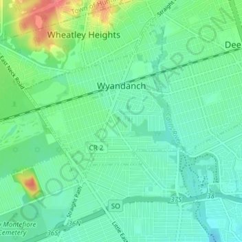
Nome: Mappa topografica Wyandanch, altitudine, rilievo.
Altitudine media: 21 m
Altitudine minima: 10 m
Altitudine massima: 58 m
Fai una donazione
Preparati per la tua prossima avventura:
In qualità di associato Amazon, questo sito riceve una commissione sugli acquisti idonei senza alcun costo aggiuntivo per te.