
Mappa topografica Colachel
Mappa interattiva
Clicca sulla mappa per visualizzare l'altitudine.
A proposito di questa mappa
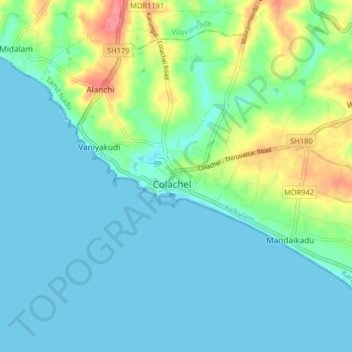
Nome: Mappa topografica Colachel, altitudine, rilievo.
Altitudine media: 16 m
Altitudine minima: -1 m
Altitudine massima: 72 m
The town is located on the western coastal side of Kanyakumari District and falls in the coordinates of 8°09′N 77°08′E / 8.15°N 77.14°E / 8.15; 77.14. The average elevation of the town is 25 meters (82 ft) above Mean Sea Level (MSL). Town is mostly characterized by a flat terrain with a few areas in the northwest region having elevation difference with other parts of the town. Generally the town is sloped gently from North to south direction and also sloping in a radial direction towards centre portion of the town from east and west directions.
Altre mappe topografiche
Clicca su una mappa per visualizzarne la topografia, l'altitudine e il rilievo.
Kumarapuram
India > Tamil Nadu > Kalkulam
Kumarapuram, Kalkulam, Kanniyakumari District, Tamil Nadu, 629166, India
Altitudine media: 76 m
Aloor
India > Tamil Nadu > Kalkulam
Aloor, Kalkulam, Kanyakumari District, Tamil Nadu, 629809, India
Altitudine media: 41 m
Kalkulam
India > Tamil Nadu > Kalkulam
Kalkulam, Kanyakumari District, Tamil Nadu, India
Altitudine media: 245 m