
Mappa topografica Ballenstedt
Clicca sulla mappa per visualizzare l'altitudine.
A proposito di questa mappa
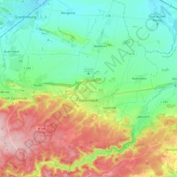
Nome: Mappa topografica Ballenstedt, altitudine, rilievo.
Luogo: Ballenstedt, Landkreis Harz, Saxony-Anhalt, 06493, Germany (51.66479 11.13783 51.79972 11.31326)
Altitudine media: 223 m
Altitudine minima: 115 m
Altitudine massima: 431 m
Altre mappe topografiche
Clicca su una mappa per visualizzarne la topografia, l'altitudine e il rilievo.
Brocken
Germany > Saxony-Anhalt > Landkreis Harz > Wernigerode
The Brocken (German pronunciation: [ˈbʁɔkn̩] ), also sometimes referred to as the Blocksberg, is a 1,141 m (3,743 ft) mountain near Schierke in the German state of Saxony-Anhalt, between the rivers Weser and Elbe. The highest peak in the Harz mountain range, and in Northern Germany, it is subalpine, yet…
Altitudine media: 963 m