
Fai una donazione
Preparati per la tua prossima avventura:
In qualità di associato Amazon, questo sito riceve una commissione sugli acquisti idonei senza alcun costo aggiuntivo per te.
Mappa topografica Pendlebury
Clicca sulla mappa per visualizzare l'altitudine.
Fai una donazione
Preparati per la tua prossima avventura:
In qualità di associato Amazon, questo sito riceve una commissione sugli acquisti idonei senza alcun costo aggiuntivo per te.
Pendlebury
Pendlebury is situated on a ridge overlooking the lower Irwell Valley, almost midway between Manchester and Bolton and is neighboured by Irlams o' th' Height, Pendleton and Clifton. Much of the boundary between Pendlebury and Clifton is defined by Slack Brook which was culverted many years ago after the area was used for landfill. Slack Brook eventually empties into the Irwell a short distance upstream from Agecroft Road Bridge (A6044). The surface of the land slopes generally upwards from southwest (Swinton) to northeast (Irwell Valley), from about 120 feet (40 m) to nearly 300 feet (90 m) above the ordnance datum. However, the topography of the land around Lumn's Lane has changed due to the dumping of mining waste from the former collieries and the area has been used as a landfill site by the Greater Manchester Waste Disposal Authority since 1982, taking ten percent of Greater Manchester's waste each year.
Fai una donazione
Preparati per la tua prossima avventura:
In qualità di associato Amazon, questo sito riceve una commissione sugli acquisti idonei senza alcun costo aggiuntivo per te.
A proposito di questa mappa
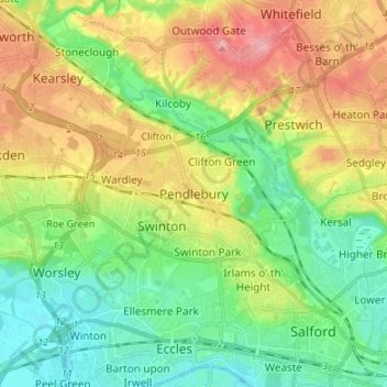
Nome: Mappa topografica Pendlebury, altitudine, rilievo.
Altitudine media: 64 m
Altitudine minima: 18 m
Altitudine massima: 138 m
Fai una donazione
Preparati per la tua prossima avventura:
In qualità di associato Amazon, questo sito riceve una commissione sugli acquisti idonei senza alcun costo aggiuntivo per te.
Altre mappe topografiche
Clicca su una mappa per visualizzarne la topografia, l'altitudine e il rilievo.
Fai una donazione
Preparati per la tua prossima avventura:
In qualità di associato Amazon, questo sito riceve una commissione sugli acquisti idonei senza alcun costo aggiuntivo per te.