
Mappa topografica Ludhiana
Mappa interattiva
Clicca sulla mappa per visualizzare l'altitudine.
A proposito di questa mappa
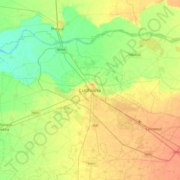
Nome: Mappa topografica Ludhiana, altitudine, rilievo.
Altitudine media: 247 m
Altitudine minima: 231 m
Altitudine massima: 264 m
Ludhiana is located at 30°54′N 75°51′E / 30.9°N 75.85°E / 30.9; 75.85. It has an average elevation of 244 metres (801 ft). Ludhiana City, to its residents, consists of the Old City and the New City. The new city primarily consists of the Civil Lines area which was historically known as the residential and official quarters of the colonial British encampment.
Altre mappe topografiche
Clicca su una mappa per visualizzarne la topografia, l'altitudine e il rilievo.
Bhatian Dhaha
India > Punjab > Ludhiana (West) Tahsil
Bhatian Dhaha, Ludhiana (West) Tahsil, Ludhiana District, Punjab, 141110, India
Altitudine media: 241 m