
Mappa topografica Dasmarinas
Mappa interattiva
Clicca sulla mappa per visualizzare l'altitudine.
A proposito di questa mappa
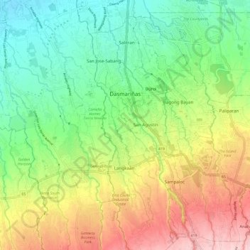
Nome: Mappa topografica Dasmarinas, altitudine, rilievo.
Luogo: Dasmarinas, Cavite, Calabarzon, 4114, Philippines (14.25680 120.92045 14.36930 121.00849)
Altitudine media: 114 m
Altitudine minima: 26 m
Altitudine massima: 246 m
Dasmariñas is partly lowland and partly hill. The Poblacion itself is elevated. From an elevation of 80 meters at the Poblacion, the land rises to 250 meters towards Silang. Generally, land near rivers and creeks are rugged. Dasmariñas is outside the typhoon belt and has no fault line constraints. Further, it is served by natural drainage system since it is traversed by several rivers and water tributaries draining to the Manila Bay. The city has yet to experience floods.