
Fai una donazione
Preparati per la tua prossima avventura:
In qualità di associato Amazon, questo sito riceve una commissione sugli acquisti idonei senza alcun costo aggiuntivo per te.
Mappa topografica Chipping Barnet
Clicca sulla mappa per visualizzare l'altitudine.
Fai una donazione
Preparati per la tua prossima avventura:
In qualità di associato Amazon, questo sito riceve una commissione sugli acquisti idonei senza alcun costo aggiuntivo per te.
Chipping Barnet
Its name is very often abbreviated to just Barnet, which is also the name of the borough of which it forms a part; the town has been part of Greater London since 1965 after the abolition of Barnet Urban District then in Hertfordshire. Chipping Barnet is also the name of the Parliamentary constituency covering the local area – the word "Chipping" denotes the presence of a market, one that was established here at the end of the 12th century and persists to this day. Chipping Barnet is one of the highest urban settlements in London, with the town centre having an elevation of about 427 feet (130 m).
Fai una donazione
Preparati per la tua prossima avventura:
In qualità di associato Amazon, questo sito riceve una commissione sugli acquisti idonei senza alcun costo aggiuntivo per te.
A proposito di questa mappa
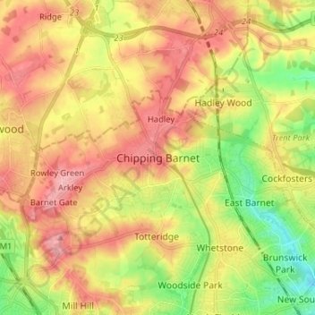
Nome: Mappa topografica Chipping Barnet, altitudine, rilievo.
Altitudine media: 95 m
Altitudine minima: 36 m
Altitudine massima: 147 m
Fai una donazione
Preparati per la tua prossima avventura:
In qualità di associato Amazon, questo sito riceve una commissione sugli acquisti idonei senza alcun costo aggiuntivo per te.
Altre mappe topografiche
Clicca su una mappa per visualizzarne la topografia, l'altitudine e il rilievo.
London Borough of Richmond upon Thames
United Kingdom > England > Greater London
Altitudine media: 18 m
Fai una donazione
Preparati per la tua prossima avventura:
In qualità di associato Amazon, questo sito riceve una commissione sugli acquisti idonei senza alcun costo aggiuntivo per te.
Norwood Grove
United Kingdom > England > Greater London
After Anderson died, ownership passed to the Nettlefold family and subsequently to Frederick Nettlefold the brother of Joseph Nettlefold and a member of the family that founded the Nettlefolds Ltd. engineering firm which later became GKN. Nettlefold is commemorated, as a result of his charitable works, by a…
Altitudine media: 58 m
Fai una donazione
Preparati per la tua prossima avventura:
In qualità di associato Amazon, questo sito riceve una commissione sugli acquisti idonei senza alcun costo aggiuntivo per te.
Fai una donazione
Preparati per la tua prossima avventura:
In qualità di associato Amazon, questo sito riceve una commissione sugli acquisti idonei senza alcun costo aggiuntivo per te.
Fai una donazione
Preparati per la tua prossima avventura:
In qualità di associato Amazon, questo sito riceve una commissione sugli acquisti idonei senza alcun costo aggiuntivo per te.
Fai una donazione
Preparati per la tua prossima avventura:
In qualità di associato Amazon, questo sito riceve una commissione sugli acquisti idonei senza alcun costo aggiuntivo per te.
Fai una donazione
Preparati per la tua prossima avventura:
In qualità di associato Amazon, questo sito riceve una commissione sugli acquisti idonei senza alcun costo aggiuntivo per te.
Pymmes Brook
United Kingdom > England > Greater London
Prior to the Anglian glaciation, a "proto-Mole-Wey" river was flowing northwards from the Weald and North Downs, through the "Finchley depression" and Palmers Green, to join the proto-Thames somewhere around Hoddesdon, at what is today an altitude of around 60 metres. It was this river which, during the course…
Altitudine media: 41 m
Fai una donazione
Preparati per la tua prossima avventura:
In qualità di associato Amazon, questo sito riceve una commissione sugli acquisti idonei senza alcun costo aggiuntivo per te.
Fai una donazione
Preparati per la tua prossima avventura:
In qualità di associato Amazon, questo sito riceve una commissione sugli acquisti idonei senza alcun costo aggiuntivo per te.
Fai una donazione
Preparati per la tua prossima avventura:
In qualità di associato Amazon, questo sito riceve una commissione sugli acquisti idonei senza alcun costo aggiuntivo per te.
Fai una donazione
Preparati per la tua prossima avventura:
In qualità di associato Amazon, questo sito riceve una commissione sugli acquisti idonei senza alcun costo aggiuntivo per te.